Morón geodata
Morón (Ciego de Ávila) is a seat of a second-order administrative division; located in Cuba in America/Havana (GMT-4) time zone. With population of 66,060 people, there are 34 cities with bigger population in this country. Compared to other cities in Cuba, 54.1% of cities are located further ↑North; 63% of cities are located further ←West and 86.2% of cities have higher elevation than Morón. Note1


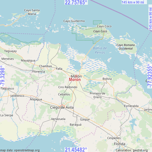
Morón GPS coordinates[2]
22° 6' 27.864" North, 78° 37' 36.012" West
| Map corner | latitude | longitude |
|---|---|---|
| Upper-left | 22.75765°, | -79.3298° |
| Center: | 22.10774°, | -78.62667° |
| Lower-right: | 21.45482°, | -77.92355° |
| Map W x H: | 144.9×144.9 km | = 90×90mi |
| max Lat: | 23.15917° ⇑54.1% North |
| Morón: | 22.10774° |
| min Lat: | ⇓45.9% South 19.90553° |
| min Long | Morón | max Long |
| -84.28599° | -78.62667° | -74.15181° |
| W 63%⇐ | ⇒37% E |
Elevation
Elevation of Morón is 14 m = 46 ft, and this is 54.6 m = 179 ft below average elevation for this country.
| Max E: |
761 m = 2497 ft | 86.2% |
| Avg. | 68.6 m = 225 ft | |
| Morón | 14 m = 46 ft | |
Min E: |
3 m = 10 ft | 13.8% |
See also: Morón elevation on elevation.city.
Geographical zone
Morón is located in North Torrid zone (between Equator and Tropic of Cancer). Distance of this Northern Tropic circle is 147.8 km =91.8 mi to North.| Distance of | km | miles | from Morón |
|---|---|---|---|
| North Pole | 7548.9 | 4690.7 | to North |
| Arctic Circle | 4943 | 3071.4 | to North |
| Tropic Cancer | 147.8 | 91.8 | to North |
| Equator | 2458.2 | 1527.5 | to South |


Nearby cities:
15 places around Morón: (largest is in red/bold)
• Baraguá
47.3 km =29.4 mi,  179°
179°
• Bolivia
29.8 km =18.5 mi,  95°
95°
• Carlos Manuel de Céspedes
69 km =42.9 mi,  149°
149°
• Chambas
31 km =19.3 mi,  288°
288°
• Ciego de Ávila
32.9 km =20.4 mi,  205°
205°
• Ciro Redondo
12.6 km =7.8 mi,  218°
218°
• Esmeralda
59.8 km =37.2 mi,  118°
118°
• Florencia
36 km =22.4 mi,  276°
276°
• Gaspar
41.9 km =26 mi,  168°
168°
• Jatibonico
58.8 km =36.5 mi,  251°
251°
• Majagua
44.2 km =27.5 mi,  241°
241°
• Primero de Enero
27.1 km =16.8 mi,  131°
131°
• Taguasco
66.7 km =41.4 mi,  259°
259°
• Venezuela
44.6 km =27.7 mi,  202°
202°
• Yaguajay
67.3 km =41.8 mi, 291°
Sources, notices
• [Note1] Compared only with cities in Cuba existing in our database
• [Src1] Map data: © OpenStreetMap contributors (CC-BY-SA)
• [Src2] Other city data from geonames.org with taken over terms of usage.
• [Src3] Geographical zone / Annual Mean Temperature by Robert A. Rohde @ Wikipedia
