Gaspar geodata
Gaspar (Ciego de Ávila) is a seat of a second-order administrative division; located in Cuba in America/Havana (GMT-4) time zone. In our database, there are 154 cities with bigger population. Compared to other cities in Cuba, 64.6% of cities are located further ↑North; 64.1% of cities are located further ←West and 80.1% of cities have higher elevation than Gaspar. Note1


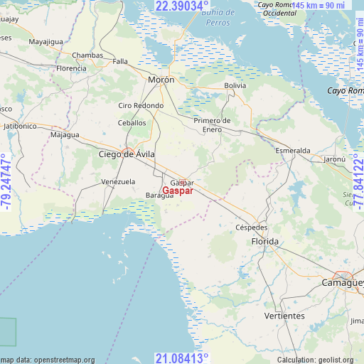
Gaspar GPS coordinates[2]
21° 44' 19.392" North, 78° 32' 39.624" West
| Map corner | latitude | longitude |
|---|---|---|
| Upper-left | 22.39034°, | -79.24747° |
| Center: | 21.73872°, | -78.54434° |
| Lower-right: | 21.08413°, | -77.84122° |
| Map W x H: | 145.2×145.2 km | = 90.2×90.2mi |
| max Lat: | 23.15917° ⇑64.6% North |
| Gaspar: | 21.73872° |
| min Lat: | ⇓35.4% South 19.90553° |
| min Long | Gaspar | max Long |
| -84.28599° | -78.54434° | -74.15181° |
| W 64.1%⇐ | ⇒35.9% E |
Elevation
Elevation of Gaspar is 21 m = 69 ft, and this is 47.6 m = 156 ft below average elevation for this country.
| Max E: |
761 m = 2497 ft | 80.1% |
| Avg. | 68.6 m = 225 ft | |
| Gaspar | 21 m = 69 ft | |
Min E: |
3 m = 10 ft | 19.9% |
See also: Cuba elevation on elevation.city.
Geographical zone
Gaspar is located in North Torrid zone (between Equator and Tropic of Cancer). Distance of this Northern Tropic circle is 188.8 km =117.3 mi to North.| Distance of | km | miles | from Gaspar |
|---|---|---|---|
| North Pole | 7589.9 | 4716.1 | to North |
| Arctic Circle | 4984.1 | 3097 | to North |
| Tropic Cancer | 188.8 | 117.3 | to North |
| Equator | 2417.1 | 1501.9 | to South |


Nearby cities:
15 places around Gaspar: (largest is in red/bold)
• Baraguá
10.5 km =6.5 mi,  233°
233°
• Bolivia
43.9 km =27.3 mi,  28°
28°
• Carlos Manuel de Céspedes
32.6 km =20.3 mi,  123°
123°
• Chambas
63.4 km =39.4 mi,  323°
323°
• Ciego de Ávila
25.1 km =15.6 mi,  296°
296°
• Ciro Redondo
35.3 km =21.9 mi,  332°
332°
• El Caney
49.2 km =30.6 mi,  172°
172°
• Esmeralda
45.8 km =28.5 mi,  74°
74°
• Florencia
63.3 km =39.3 mi, 315°
• Florida
40.6 km =25.2 mi,  125°
125°
• Majagua
51.4 km =31.9 mi,  292°
292°
• Morón
41.9 km =26 mi,  348°
348°
• Primero de Enero
25.7 km =16 mi, 26°
• Venezuela
25.7 km =16 mi,  269°
269°
• Vertientes
67.2 km =41.8 mi,  142°
142°
Sources, notices
• [Note1] Compared only with cities in Cuba existing in our database
• [Src1] Map data: © OpenStreetMap contributors (CC-BY-SA)
• [Src2] Other city data from geonames.org with taken over terms of usage.
• [Src3] Geographical zone / Annual Mean Temperature by Robert A. Rohde @ Wikipedia
