Baraguá geodata
Baraguá (Ciego de Ávila) is a seat of a second-order administrative division; located in Cuba in America/Havana (GMT-4) time zone. With population of 15,268 people, there are 126 cities with bigger population in this country. Compared to other cities in Cuba, 66.3% of cities are located further ↑North; 63.5% of cities are located further ←West and 96.1% of cities have higher elevation than Baraguá. Note1


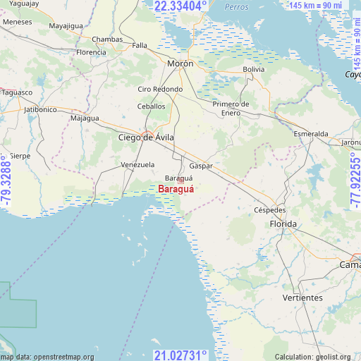
Baraguá GPS coordinates[2]
21° 40' 55.776" North, 78° 37' 32.412" West
| Map corner | latitude | longitude |
|---|---|---|
| Upper-left | 22.33404°, | -79.3288° |
| Center: | 21.68216°, | -78.62567° |
| Lower-right: | 21.02731°, | -77.92255° |
| Map W x H: | 145.3×145.3 km | = 90.3×90.3mi |
| max Lat: | 23.15917° ⇑66.3% North |
| Baraguá: | 21.68216° |
| min Lat: | ⇓33.7% South 19.90553° |
| min Long | Baraguá | max Long |
| -84.28599° | -78.62567° | -74.15181° |
| W 63.5%⇐ | ⇒36.5% E |
Elevation
Elevation of Baraguá is 9 m = 30 ft, and this is 59.6 m = 196 ft below average elevation for this country.
| Max E: |
761 m = 2497 ft | 96.1% |
| Avg. | 68.6 m = 225 ft | |
| Baraguá | 9 m = 30 ft | |
Min E: |
3 m = 10 ft | 3.9% |
See also: Cuba elevation on elevation.city.
Geographical zone
Baraguá is located in North Torrid zone (between Equator and Tropic of Cancer). Distance of this Northern Tropic circle is 195.1 km =121.2 mi to North.| Distance of | km | miles | from Baraguá |
|---|---|---|---|
| North Pole | 7596.2 | 4720.1 | to North |
| Arctic Circle | 4990.3 | 3100.8 | to North |
| Tropic Cancer | 195.1 | 121.2 | to North |
| Equator | 2410.8 | 1498 | to South |


Nearby cities:
15 places around Baraguá: (largest is in red/bold)
• Bolivia
53.6 km =33.3 mi,  33°
33°
• Carlos Manuel de Céspedes
37.4 km =23.2 mi,  108°
108°
• Chambas
64.3 km =40 mi,  332°
332°
• Ciego de Ávila
22.5 km =14 mi,  321°
321°
• Ciro Redondo
38.3 km =23.8 mi,  347°
347°
• El Caney
45 km =28 mi,  160°
160°
• Esmeralda
55.8 km =34.7 mi,  70°
70°
• Florencia
62.8 km =39 mi, 325°
• Florida
44.9 km =27.9 mi, 112°
• Gaspar
10.5 km =6.5 mi,  53°
53°
• Jatibonico
63.2 km =39.3 mi,  297°
297°
• Majagua
46.9 km =29.1 mi, 303°
• Morón
47.3 km =29.4 mi,  359°
359°
• Primero de Enero
35.5 km =22.1 mi, 34°
• Venezuela
18.4 km =11.4 mi,  289°
289°
Sources, notices
• [Note1] Compared only with cities in Cuba existing in our database
• [Src1] Map data: © OpenStreetMap contributors (CC-BY-SA)
• [Src2] Other city data from geonames.org with taken over terms of usage.
• [Src3] Geographical zone / Annual Mean Temperature by Robert A. Rohde @ Wikipedia
