Esmeralda geodata
Esmeralda (Camagüey) is a seat of a second-order administrative division; located in Cuba in America/Havana (GMT-4) time zone. With population of 20,274 people, there are 102 cities with bigger population in this country. Compared to other cities in Cuba, 62.4% of cities are located further ↑North; 68% of cities are located further ←West and 59.1% of cities have higher elevation than Esmeralda. Note1


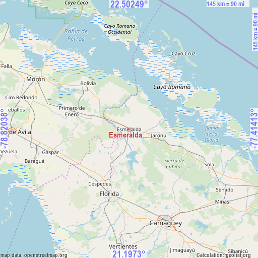
Esmeralda GPS coordinates[2]
21° 51' 5.004" North, 78° 7' 2.1" West
| Map corner | latitude | longitude |
|---|---|---|
| Upper-left | 22.50249°, | -78.82038° |
| Center: | 21.85139°, | -78.11725° |
| Lower-right: | 21.1973°, | -77.41413° |
| Map W x H: | 145.1×145.1 km | = 90.2×90.2mi |
| max Lat: | 23.15917° ⇑62.4% North |
| Esmeralda: | 21.85139° |
| min Lat: | ⇓37.6% South 19.90553° |
| min Long | Esmeralda | max Long |
| -84.28599° | -78.11725° | -74.15181° |
| W 68%⇐ | ⇒32% E |
Elevation
Elevation of Esmeralda is 38 m = 125 ft, and this is 30.6 m = 100 ft below average elevation for this country.
| Max E: |
761 m = 2497 ft | 59.1% |
| Avg. | 68.6 m = 225 ft | |
| Esmeralda | 38 m = 125 ft | |
Min E: |
3 m = 10 ft | 40.9% |
See also: Cuba elevation on elevation.city.
Geographical zone
Esmeralda is located in North Torrid zone (between Equator and Tropic of Cancer). Distance of this Northern Tropic circle is 176.3 km =109.5 mi to North.| Distance of | km | miles | from Esmeralda |
|---|---|---|---|
| North Pole | 7577.4 | 4708.4 | to North |
| Arctic Circle | 4971.5 | 3089.1 | to North |
| Tropic Cancer | 176.3 | 109.5 | to North |
| Equator | 2429.6 | 1509.7 | to South |


Nearby cities:
15 places around Esmeralda: (largest is in red/bold)
• Baraguá
55.8 km =34.7 mi,  250°
250°
• Bolivia
34.5 km =21.4 mi,  318°
318°
• Camagüey
56.3 km =35 mi,  158°
158°
• Carlos Manuel de Céspedes
35.1 km =21.8 mi,  209°
209°
• Ciego de Ávila
66.5 km =41.3 mi,  268°
268°
• Ciro Redondo
63.3 km =39.3 mi,  287°
287°
• Cubitas
39.9 km =24.8 mi,  112°
112°
• El Caney
72.1 km =44.8 mi, 211°
• Florida
37.9 km =23.5 mi,  197°
197°
• Gaspar
45.8 km =28.5 mi, 254°
• Minas
66.2 km =41.1 mi,  127°
127°
• Morón
59.8 km =37.2 mi,  298°
298°
• Primero de Enero
34 km =21.1 mi, 287°
• Venezuela
70.9 km =44.1 mi,  259°
259°
• Vertientes
66 km =41 mi,  182°
182°
Sources, notices
• [Note1] Compared only with cities in Cuba existing in our database
• [Src1] Map data: © OpenStreetMap contributors (CC-BY-SA)
• [Src2] Other city data from geonames.org with taken over terms of usage.
• [Src3] Geographical zone / Annual Mean Temperature by Robert A. Rohde @ Wikipedia
