Abreus geodata
Abreus (Cienfuegos) is a populated place; located in Cuba in America/Havana (GMT-4) time zone. With population of 16,711 people, there are 122 cities with bigger population in this country. Compared to other cities in Cuba, 50.3% of cities are located further ↓South; 60.2% of cities are located further →East and 67.4% of cities have higher elevation than Abreus. Note1


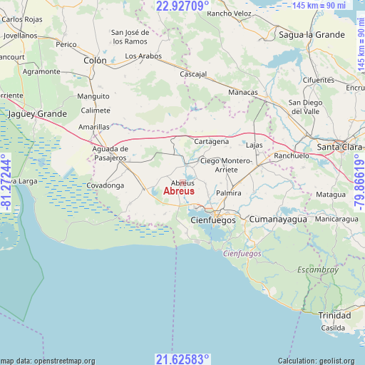
Abreus GPS coordinates[2]
22° 16' 40.692" North, 80° 34' 9.516" West
| Map corner | latitude | longitude |
|---|---|---|
| Upper-left | 22.92709°, | -81.27244° |
| Center: | 22.27797°, | -80.56931° |
| Lower-right: | 21.62583°, | -79.86619° |
| Map W x H: | 144.7×144.7 km | = 89.9×89.9mi |
| max Lat: | 23.15917° ⇑49.7% North |
| Abreus: | 22.27797° |
| min Lat: | ⇓50.3% South 19.90553° |
| min Long | Abreus | max Long |
| -84.28599° | -80.56931° | -74.15181° |
| W 39.8%⇐ | ⇒60.2% E |
Elevation
Elevation of Abreus is 29 m = 95 ft, and this is 39.6 m = 130 ft below average elevation for this country.
| Max E: |
761 m = 2497 ft | 67.4% |
| Avg. | 68.6 m = 225 ft | |
| Abreus | 29 m = 95 ft | |
Min E: |
3 m = 10 ft | 32.6% |
See also: Cuba elevation on elevation.city.
Geographical zone
Abreus is located in North Torrid zone (between Equator and Tropic of Cancer). Distance of this Northern Tropic circle is 128.8 km =80 mi to North.| Distance of | km | miles | from Abreus |
|---|---|---|---|
| North Pole | 7530 | 4678.9 | to North |
| Arctic Circle | 4924.1 | 3059.7 | to North |
| Tropic Cancer | 128.8 | 80 | to North |
| Equator | 2477.1 | 1539.2 | to South |


Nearby cities:
15 places around Abreus: (largest is in red/bold)
• Aguada de Pasajeros
31 km =19.3 mi,  292°
292°
• Calimete
45.2 km =28.1 mi,  309°
309°
• Cienfuegos
19.1 km =11.9 mi,  138°
138°
• Colón
60.1 km =37.3 mi,  324°
324°
• Cruces
31.6 km =19.6 mi,  76°
76°
• Cumanayagua
40.2 km =25 mi,  110°
110°
• Esperanza
52.1 km =32.4 mi,  68°
68°
• Lajas
32.2 km =20 mi,  61°
61°
• Los Arabos
52.6 km =32.7 mi,  342°
342°
• Manguito
49.4 km =30.7 mi, 314°
• Manicaragua
62.4 km =38.8 mi,  103°
103°
• Palmira
18.8 km =11.7 mi, 102°
• Ranchuelo
44.3 km =27.5 mi, 76°
• Rodas
7.2 km =4.5 mi,  10°
10°
• Santo Domingo
48 km =29.8 mi,  44°
44°
Sources, notices
• [Note1] Compared only with cities in Cuba existing in our database
• [Src1] Map data: © OpenStreetMap contributors (CC-BY-SA)
• [Src2] Other city data from geonames.org with taken over terms of usage.
• [Src3] Geographical zone / Annual Mean Temperature by Robert A. Rohde @ Wikipedia
