Lajas geodata
Lajas (Cienfuegos) is a seat of a second-order administrative division; located in Cuba in America/Havana (GMT-4) time zone. With population of 22,602 people, there are 98 cities with bigger population in this country. Compared to other cities in Cuba, 56.4% of cities are located further ↓South; 57.5% of cities are located further →East and 71.8% of cities have lower elevation than Lajas. Note1


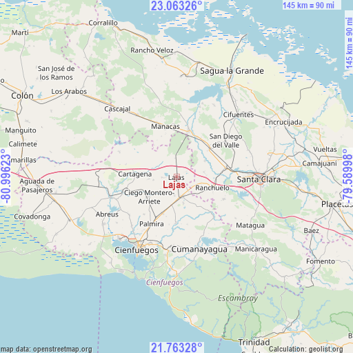
Lajas GPS coordinates[2]
22° 24' 53.244" North, 80° 17' 35.16" West
| Map corner | latitude | longitude |
|---|---|---|
| Upper-left | 23.06326°, | -80.99623° |
| Center: | 22.41479°, | -80.2931° |
| Lower-right: | 21.76328°, | -79.58998° |
| Map W x H: | 144.5×144.5 km | = 89.8×89.8mi |
| max Lat: | 23.15917° ⇑43.6% North |
| Lajas: | 22.41479° |
| min Lat: | ⇓56.4% South 19.90553° |
| min Long | Lajas | max Long |
| -84.28599° | -80.2931° | -74.15181° |
| W 42.5%⇐ | ⇒57.5% E |
Elevation
Elevation of Lajas is 78 m = 256 ft, and this is 9.4 m = 31 ft above average elevation for this country.
| Max E: |
761 m = 2497 ft | 28.2% |
| Lajas | 78 m 256 ft | |
| Avg. | 68.6 m = 225 ft | |
Min E: |
3 m = 10 ft | 71.8% |
See also: Cuba elevation on elevation.city.
Geographical zone
Lajas is located in North Torrid zone (between Equator and Tropic of Cancer). Distance of this Northern Tropic circle is 113.6 km =70.6 mi to North.| Distance of | km | miles | from Lajas |
|---|---|---|---|
| North Pole | 7514.8 | 4669.5 | to North |
| Arctic Circle | 4908.9 | 3050.2 | to North |
| Tropic Cancer | 113.6 | 70.6 | to North |
| Equator | 2492.3 | 1548.6 | to South |


Nearby cities:
15 places around Lajas: (largest is in red/bold)
• Abreus
32.2 km =20 mi,  241°
241°
• Calabazar de Sagua
48.2 km =30 mi,  57°
57°
• Cienfuegos
33.5 km =20.8 mi,  208°
208°
• Cifuentes
36.1 km =22.4 mi,  43°
43°
• Cruces
8.4 km =5.2 mi,  163°
163°
• Cumanayagua
30.6 km =19 mi, 162°
• Esperanza
20.5 km =12.7 mi,  79°
79°
• Manicaragua
43.7 km =27.2 mi,  132°
132°
• Palmira
21.8 km =13.5 mi, 207°
• Quemado de Güines
41.7 km =25.9 mi,  5°
5°
• Ranchuelo
15.4 km =9.6 mi,  107°
107°
• Rodas
28.2 km =17.5 mi,  253°
253°
• Sagua la Grande
49 km =30.4 mi,  27°
27°
• Santa Clara
33.8 km =21 mi,  91°
91°
• Santo Domingo
19.8 km =12.3 mi,  15°
15°
Sources, notices
• [Note1] Compared only with cities in Cuba existing in our database
• [Src1] Map data: © OpenStreetMap contributors (CC-BY-SA)
• [Src2] Other city data from geonames.org with taken over terms of usage.
• [Src3] Geographical zone / Annual Mean Temperature by Robert A. Rohde @ Wikipedia
