Manicaragua geodata
Manicaragua (Villa Clara) is a seat of a second-order administrative division; located in Cuba in America/Havana (GMT-4) time zone. With population of 41,532 people, there are 60 cities with bigger population in this country. Compared to other cities in Cuba, 52.5% of cities are located further ↑North; 50.8% of cities are located further →East and 92.8% of cities have lower elevation than Manicaragua. Note1


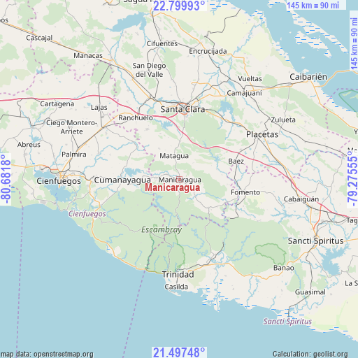
Manicaragua GPS coordinates[2]
22° 9' 0.756" North, 79° 58' 43.212" West
| Map corner | latitude | longitude |
|---|---|---|
| Upper-left | 22.79993°, | -80.6818° |
| Center: | 22.15021°, | -79.97867° |
| Lower-right: | 21.49748°, | -79.27555° |
| Map W x H: | 144.8×144.8 km | = 90×90mi |
| max Lat: | 23.15917° ⇑52.5% North |
| Manicaragua: | 22.15021° |
| min Lat: | ⇓47.5% South 19.90553° |
| min Long | Manicaragua | max Long |
| -84.28599° | -79.97867° | -74.15181° |
| W 49.2%⇐ | ⇒50.8% E |
Elevation
Elevation of Manicaragua is 144 m = 472 ft, and this is 75.4 m = 247 ft above average elevation for this country.
| Max E: |
761 m = 2497 ft | 7.2% |
| Manicaragua | 144 m 472 ft | |
| Avg. | 68.6 m = 225 ft | |
Min E: |
3 m = 10 ft | 92.8% |
See also: Manicaragua elevation on elevation.city.
Geographical zone
Manicaragua is located in North Torrid zone (between Equator and Tropic of Cancer). Distance of this Northern Tropic circle is 143 km =88.9 mi to North.| Distance of | km | miles | from Manicaragua |
|---|---|---|---|
| North Pole | 7544.2 | 4687.7 | to North |
| Arctic Circle | 4938.3 | 3068.5 | to North |
| Tropic Cancer | 143 | 88.9 | to North |
| Equator | 2462.9 | 1530.4 | to South |


Nearby cities:
15 places around Manicaragua: (largest is in red/bold)
• Camajuaní
43.7 km =27.2 mi,  36°
36°
• Camajuaní
43.9 km =27.3 mi,  32°
32°
• Cienfuegos
48.2 km =30 mi,  269°
269°
• Condado
33.6 km =20.9 mi,  154°
154°
• Cruces
36.8 km =22.9 mi,  305°
305°
• Cumanayagua
23.2 km =14.4 mi, 270°
• Esperanza
35.2 km =21.9 mi,  339°
339°
• Fomento
27 km =16.8 mi,  100°
100°
• Lajas
43.7 km =27.2 mi, 312°
• Palmira
43.7 km =27.2 mi,  283°
283°
• Placetas
37.9 km =23.5 mi,  61°
61°
• Ranchuelo
30.4 km =18.9 mi,  324°
324°
• Santa Clara
28.6 km =17.8 mi,  2°
2°
• Topes de Collantes
26.5 km =16.5 mi,  189°
189°
• Trinidad
38.7 km =24 mi,  180°
180°
Sources, notices
• [Note1] Compared only with cities in Cuba existing in our database
• [Src1] Map data: © OpenStreetMap contributors (CC-BY-SA)
• [Src2] Other city data from geonames.org with taken over terms of usage.
• [Src3] Geographical zone / Annual Mean Temperature by Robert A. Rohde @ Wikipedia
