Ranchuelo geodata
Ranchuelo (Villa Clara) is a populated place; located in Cuba in America/Havana (GMT-4) time zone. With population of 43,695 people, there are 56 cities with bigger population in this country. Compared to other cities in Cuba, 54.7% of cities are located further ↓South; 54.7% of cities are located further →East and 83.4% of cities have lower elevation than Ranchuelo. Note1


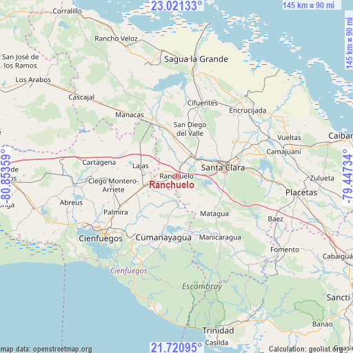
Ranchuelo GPS coordinates[2]
22° 22' 21.576" North, 80° 9' 1.656" West
| Map corner | latitude | longitude |
|---|---|---|
| Upper-left | 23.02133°, | -80.85359° |
| Center: | 22.37266°, | -80.15046° |
| Lower-right: | 21.72095°, | -79.44734° |
| Map W x H: | 144.6×144.6 km | = 89.9×89.9mi |
| max Lat: | 23.15917° ⇑45.3% North |
| Ranchuelo: | 22.37266° |
| min Lat: | ⇓54.7% South 19.90553° |
| min Long | Ranchuelo | max Long |
| -84.28599° | -80.15046° | -74.15181° |
| W 45.3%⇐ | ⇒54.7% E |
Elevation
Elevation of Ranchuelo is 108 m = 354 ft, and this is 39.4 m = 129 ft above average elevation for this country.
| Max E: |
761 m = 2497 ft | 16.6% |
| Ranchuelo | 108 m 354 ft | |
| Avg. | 68.6 m = 225 ft | |
Min E: |
3 m = 10 ft | 83.4% |
See also: Ranchuelo elevation on elevation.city.
Geographical zone
Ranchuelo is located in North Torrid zone (between Equator and Tropic of Cancer). Distance of this Northern Tropic circle is 118.3 km =73.5 mi to North.| Distance of | km | miles | from Ranchuelo |
|---|---|---|---|
| North Pole | 7519.5 | 4672.4 | to North |
| Arctic Circle | 4913.6 | 3053.2 | to North |
| Tropic Cancer | 118.3 | 73.5 | to North |
| Equator | 2487.6 | 1545.7 | to South |


Nearby cities:
15 places around Ranchuelo: (largest is in red/bold)
• Abreus
44.3 km =27.5 mi,  256°
256°
• Calabazar de Sagua
40.1 km =24.9 mi,  40°
40°
• Camajuaní
43 km =26.7 mi,  73°
73°
• Cienfuegos
39.3 km =24.4 mi,  230°
230°
• Cifuentes
32.5 km =20.2 mi,  18°
18°
• Cruces
12.8 km =8 mi,  254°
254°
• Cumanayagua
25.1 km =15.6 mi,  192°
192°
• Encrucijada
40 km =24.9 mi,  46°
46°
• Esperanza
9.9 km =6.2 mi,  33°
33°
• Lajas
15.4 km =9.6 mi,  287°
287°
• Manicaragua
30.4 km =18.9 mi,  144°
144°
• Palmira
28.7 km =17.8 mi,  239°
239°
• Rodas
41.8 km =26 mi,  265°
265°
• Santa Clara
19.5 km =12.1 mi,  78°
78°
• Santo Domingo
25.6 km =15.9 mi,  338°
338°
Sources, notices
• [Note1] Compared only with cities in Cuba existing in our database
• [Src1] Map data: © OpenStreetMap contributors (CC-BY-SA)
• [Src2] Other city data from geonames.org with taken over terms of usage.
• [Src3] Geographical zone / Annual Mean Temperature by Robert A. Rohde @ Wikipedia
