Zschorlau geodata
Zschorlau (Saxony) is a seat of a fourth-order administrative division; located in Germany in Europe/Berlin (GMT+2) time zone. With population of 5,944 people, there are 2481 cities with bigger population in this country. Compared to other cities in Germany, 51.3% of cities are located further ↑North; 89.3% of cities are located further ←West and 88.7% of cities have lower elevation than Zschorlau. Note1


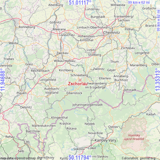
Zschorlau GPS coordinates[2]
50° 34' 0.012" North, 12° 39' 0" East
| Map corner | latitude | longitude |
|---|---|---|
| Upper-left | 51.01117°, | 11.94688° |
| Center: | 50.56667°, | 12.65° |
| Lower-right: | 50.11794°, | 13.35313° |
| Map W x H: | 99.3×99.3 km | = 61.7×61.7mi |
| max Lat: | 55.01917° ⇑51.3% North |
| Zschorlau: | 50.56667° |
| min Lat: | ⇓48.7% South 47.40724° |
| min Long | Zschorlau | max Long |
| 5.92978° | 12.65° | 14.98853° |
| W 89.3%⇐ | ⇒10.7% E |
Elevation
Elevation of Zschorlau is 501 m = 1644 ft, and this is 251.9 m = 826 ft above average elevation for this country.
| Max E: |
1256 m = 4121 ft | 11.3% |
| Zschorlau | 501 m 1644 ft | |
| Avg. | 249.1 m = 817 ft | |
Min E: |
-5 m = -16 ft | 88.7% |
See also: Germany elevation on elevation.city.
Geographical zone
Zschorlau is located in North temperate zone (between Tropic of Cancer and the Arctic Circle). Distance of this North polar circle is 1778.7 km =1105.2 mi to North.| Distance of | km | miles | from Zschorlau |
|---|---|---|---|
| North Pole | 4384.6 | 2724.5 | to North |
| Arctic Circle | 1778.7 | 1105.2 | to North |
| Tropic Cancer | 3016.6 | 1874.4 | to South |
| Equator | 5622.5 | 3493.7 | to South |


Nearby cities:
15 places around Zschorlau: (largest is in red/bold)
• Aue
4.8 km =3 mi,  56°
56°
• Bad Schlema
4.3 km =2.7 mi,  22°
22°
• Beierfeld
9.9 km =6.2 mi,  90°
90°
• Bernsbach
8.4 km =5.2 mi,  82°
82°
• Bockau
3.8 km =2.4 mi,  136°
136°
• Eibenstock
8.8 km =5.5 mi,  203°
203°
• Grünhain
11.2 km =7 mi, 82°
• Hartenstein
10.7 km =6.6 mi,  7°
7°
• Kirchberg
10.8 km =6.7 mi,  304°
304°
• Lauter
6 km =3.7 mi, 94°
• Lößnitz
8.4 km =5.2 mi,  43°
43°
• Schneeberg
3.2 km =2 mi,  348°
348°
• Schwarzenberg
10.1 km =6.3 mi,  108°
108°
• Sosa
7.5 km =4.7 mi,  179°
179°
• Stützengrün
9 km =5.6 mi,  245°
245°
Sources, notices
• [Note1] Compared only with cities in Germany existing in our database
• [Src1] Map data: © OpenStreetMap contributors (CC-BY-SA)
• [Src2] Other city data from geonames.org with taken over terms of usage.
• [Src3] Geographical zone / Annual Mean Temperature by Robert A. Rohde @ Wikipedia
