Lößnitz geodata
Lößnitz (Saxony) is a populated place; located in Germany in Europe/Berlin (GMT+2) time zone. With population of 10,433 people, there are 1579 cities with bigger population in this country. Compared to other cities in Germany, 50.1% of cities are located further ↓South; 90.1% of cities are located further ←West and 79.5% of cities have lower elevation than Lößnitz. Note1


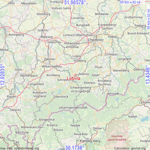
Lößnitz GPS coordinates[2]
50° 37' 18.516" North, 12° 43' 53.292" East
| Map corner | latitude | longitude |
|---|---|---|
| Upper-left | 51.06578°, | 12.02835° |
| Center: | 50.62181°, | 12.73147° |
| Lower-right: | 50.1736°, | 13.4346° |
| Map W x H: | 99.2×99.2 km | = 61.6×61.6mi |
| max Lat: | 55.01917° ⇑49.9% North |
| Lößnitz: | 50.62181° |
| min Lat: | ⇓50.1% South 47.40724° |
| min Long | Lößnitz | max Long |
| 5.92978° | 12.73147° | 14.98853° |
| W 90.1%⇐ | ⇒9.9% E |
Elevation
Elevation of Lößnitz is 430 m = 1411 ft, and this is 180.9 m = 594 ft above average elevation for this country.
| Max E: |
1256 m = 4121 ft | 20.5% |
| Lößnitz | 430 m 1411 ft | |
| Avg. | 249.1 m = 817 ft | |
Min E: |
-5 m = -16 ft | 79.5% |
See also: Germany elevation on elevation.city.
Geographical zone
Lößnitz is located in North temperate zone (between Tropic of Cancer and the Arctic Circle). Distance of this North polar circle is 1772.6 km =1101.4 mi to North.| Distance of | km | miles | from Lößnitz |
|---|---|---|---|
| North Pole | 4378.4 | 2720.6 | to North |
| Arctic Circle | 1772.6 | 1101.4 | to North |
| Tropic Cancer | 3022.7 | 1878.2 | to South |
| Equator | 5628.6 | 3497.4 | to South |


Nearby cities:
15 places around Lößnitz: (largest is in red/bold)
• Aue
3.9 km =2.4 mi,  206°
206°
• Bad Schlema
4.7 km =2.9 mi,  242°
242°
• Beierfeld
7.5 km =4.7 mi,  146°
146°
• Bernsbach
5.7 km =3.5 mi, 153°
• Bockau
9.4 km =5.8 mi,  199°
199°
• Dorfchemnitz
8.7 km =5.4 mi,  57°
57°
• Grünhain
7.1 km =4.4 mi,  130°
130°
• Hartenstein
6.3 km =3.9 mi,  315°
315°
• Lauter
6.6 km =4.1 mi,  177°
177°
• Schneeberg
7 km =4.3 mi, 244°
• Schwarzenberg
10.1 km =6.3 mi,  157°
157°
• Stollberg
10.4 km =6.5 mi,  19°
19°
• Wildenfels
10 km =6.2 mi,  300°
300°
• Zschorlau
8.4 km =5.2 mi,  223°
223°
• Zwönitz
5.6 km =3.5 mi,  80°
80°
Sources, notices
• [Note1] Compared only with cities in Germany existing in our database
• [Src1] Map data: © OpenStreetMap contributors (CC-BY-SA)
• [Src2] Other city data from geonames.org with taken over terms of usage.
• [Src3] Geographical zone / Annual Mean Temperature by Robert A. Rohde @ Wikipedia
