Sosa geodata
Sosa (Saxony) is a populated place; located in Germany in Europe/Berlin (GMT+2) time zone. With population of 2,223 people, there are 4778 cities with bigger population in this country. Compared to other cities in Germany, 52.8% of cities are located further ↑North; 89.4% of cities are located further ←West and 95.4% of cities have lower elevation than Sosa. Note1


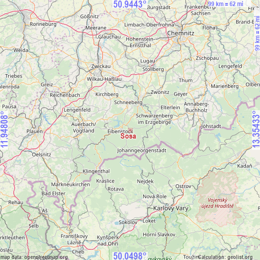
Sosa GPS coordinates[2]
50° 29' 57.012" North, 12° 39' 4.32" East
| Map corner | latitude | longitude |
|---|---|---|
| Upper-left | 50.9443°, | 11.94808° |
| Center: | 50.49917°, | 12.6512° |
| Lower-right: | 50.0498°, | 13.35433° |
| Map W x H: | 99.5×99.5 km | = 61.8×61.8mi |
| max Lat: | 55.01917° ⇑52.8% North |
| Sosa: | 50.49917° |
| min Lat: | ⇓47.2% South 47.40724° |
| min Long | Sosa | max Long |
| 5.92978° | 12.6512° | 14.98853° |
| W 89.4%⇐ | ⇒10.6% E |
Elevation
Elevation of Sosa is 609 m = 1998 ft, and this is 359.9 m = 1181 ft above average elevation for this country.
| Max E: |
1256 m = 4121 ft | 4.6% |
| Sosa | 609 m 1998 ft | |
| Avg. | 249.1 m = 817 ft | |
Min E: |
-5 m = -16 ft | 95.4% |
See also: Germany elevation on elevation.city.
Geographical zone
Sosa is located in North temperate zone (between Tropic of Cancer and the Arctic Circle). Distance of this North polar circle is 1786.2 km =1109.9 mi to North.| Distance of | km | miles | from Sosa |
|---|---|---|---|
| North Pole | 4392.1 | 2729.1 | to North |
| Arctic Circle | 1786.2 | 1109.9 | to North |
| Tropic Cancer | 3009.1 | 1869.8 | to South |
| Equator | 5615 | 3489 | to South |


Nearby cities:
15 places around Sosa: (largest is in red/bold)
• Aue
10.9 km =6.8 mi,  21°
21°
• Bad Schlema
11.6 km =7.2 mi,  7°
7°
• Bockau
5.4 km =3.4 mi,  27°
27°
• Breitenbrunn
8.6 km =5.3 mi,  107°
107°
• Eibenstock
3.7 km =2.3 mi,  261°
261°
• Erlabrunn
5 km =3.1 mi,  126°
126°
• Johanngeorgenstadt
8.5 km =5.3 mi,  150°
150°
• Lauter
9.2 km =5.7 mi,  40°
40°
• Morgenröthe-Rautenkranz
11.4 km =7.1 mi,  238°
238°
• Rittersgrün
10.3 km =6.4 mi,  101°
101°
• Schneeberg
10.6 km =6.6 mi,  356°
356°
• Schwarzenberg
10.4 km =6.5 mi,  65°
65°
• Schönheide
9.2 km =5.7 mi,  273°
273°
• Stützengrün
9.2 km =5.7 mi,  294°
294°
• Zschorlau
7.5 km =4.7 mi, 359°
Sources, notices
• [Note1] Compared only with cities in Germany existing in our database
• [Src1] Map data: © OpenStreetMap contributors (CC-BY-SA)
• [Src2] Other city data from geonames.org with taken over terms of usage.
• [Src3] Geographical zone / Annual Mean Temperature by Robert A. Rohde @ Wikipedia
