Hartenstein geodata
Hartenstein (Saxony) is a populated place; located in Germany in Europe/Berlin (GMT+2) time zone. With population of 5,043 people, there are 2809 cities with bigger population in this country. Compared to other cities in Germany, 51.1% of cities are located further ↓South; 89.5% of cities are located further ←West and 70.9% of cities have lower elevation than Hartenstein. Note1


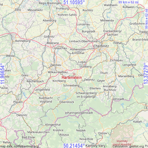
Hartenstein GPS coordinates[2]
50° 39' 44.496" North, 12° 40' 10.776" East
| Map corner | latitude | longitude |
|---|---|---|
| Upper-left | 51.10595°, | 11.96654° |
| Center: | 50.66236°, | 12.66966° |
| Lower-right: | 50.21454°, | 13.37279° |
| Map W x H: | 99.1×99.1 km | = 61.6×61.6mi |
| max Lat: | 55.01917° ⇑48.9% North |
| Hartenstein: | 50.66236° |
| min Lat: | ⇓51.1% South 47.40724° |
| min Long | Hartenstein | max Long |
| 5.92978° | 12.66966° | 14.98853° |
| W 89.5%⇐ | ⇒10.5% E |
Elevation
Elevation of Hartenstein is 365 m = 1198 ft, and this is 115.9 m = 380 ft above average elevation for this country.
| Max E: |
1256 m = 4121 ft | 29.1% |
| Hartenstein | 365 m 1198 ft | |
| Avg. | 249.1 m = 817 ft | |
Min E: |
-5 m = -16 ft | 70.9% |
See also: Germany elevation on elevation.city.
Geographical zone
Hartenstein is located in North temperate zone (between Tropic of Cancer and the Arctic Circle). Distance of this North polar circle is 1768 km =1098.6 mi to North.| Distance of | km | miles | from Hartenstein |
|---|---|---|---|
| North Pole | 4373.9 | 2717.8 | to North |
| Arctic Circle | 1768 | 1098.6 | to North |
| Tropic Cancer | 3027.2 | 1881 | to South |
| Equator | 5633.1 | 3500.2 | to South |


Nearby cities:
15 places around Hartenstein: (largest is in red/bold)
• Aue
8.4 km =5.2 mi,  161°
161°
• Bad Schlema
6.7 km =4.2 mi,  178°
178°
• Gersdorf
10.3 km =6.4 mi,  18°
18°
• Hohndorf
8.7 km =5.4 mi,  5°
5°
• Lichtenstein
10.8 km =6.7 mi,  345°
345°
• Lugau
10.1 km =6.3 mi,  33°
33°
• Lößnitz
6.3 km =3.9 mi,  135°
135°
• Niederdorf
10.8 km =6.7 mi,  49°
49°
• Oelsnitz
7.4 km =4.6 mi, 17°
• Reinsdorf
9 km =5.6 mi,  296°
296°
• Schneeberg
7.8 km =4.8 mi,  194°
194°
• Stollberg
9.4 km =5.8 mi,  55°
55°
• Wildenfels
4.3 km =2.7 mi,  278°
278°
• Zschorlau
10.7 km =6.6 mi, 187°
• Zwönitz
10.5 km =6.5 mi,  109°
109°
Sources, notices
• [Note1] Compared only with cities in Germany existing in our database
• [Src1] Map data: © OpenStreetMap contributors (CC-BY-SA)
• [Src2] Other city data from geonames.org with taken over terms of usage.
• [Src3] Geographical zone / Annual Mean Temperature by Robert A. Rohde @ Wikipedia
