Zschopau geodata
Zschopau (Saxony) is a populated place; located in Germany in Europe/Berlin (GMT+2) time zone. With population of 11,705 people, there are 1402 cities with bigger population in this country. Compared to other cities in Germany, 53.2% of cities are located further ↓South; 92.8% of cities are located further ←West and 69.5% of cities have lower elevation than Zschopau. Note1


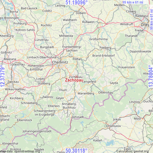
Zschopau GPS coordinates[2]
50° 44' 53.448" North, 13° 4' 36.876" East
| Map corner | latitude | longitude |
|---|---|---|
| Upper-left | 51.19096°, | 12.37379° |
| Center: | 50.74818°, | 13.07691° |
| Lower-right: | 50.30118°, | 13.78004° |
| Map W x H: | 98.9×98.9 km | = 61.5×61.5mi |
| max Lat: | 55.01917° ⇑46.8% North |
| Zschopau: | 50.74818° |
| min Lat: | ⇓53.2% South 47.40724° |
| min Long | Zschopau | max Long |
| 5.92978° | 13.07691° | 14.98853° |
| W 92.8%⇐ | ⇒7.2% E |
Elevation
Elevation of Zschopau is 355 m = 1165 ft, and this is 105.9 m = 347 ft above average elevation for this country.
| Max E: |
1256 m = 4121 ft | 30.5% |
| Zschopau | 355 m 1165 ft | |
| Avg. | 249.1 m = 817 ft | |
Min E: |
-5 m = -16 ft | 69.5% |
See also: Germany elevation on elevation.city.
Geographical zone
Zschopau is located in North temperate zone (between Tropic of Cancer and the Arctic Circle). Distance of this North polar circle is 1758.5 km =1092.7 mi to North.| Distance of | km | miles | from Zschopau |
|---|---|---|---|
| North Pole | 4364.4 | 2711.9 | to North |
| Arctic Circle | 1758.5 | 1092.7 | to North |
| Tropic Cancer | 3036.7 | 1886.9 | to South |
| Equator | 5642.7 | 3506.2 | to South |


Nearby cities:
15 places around Zschopau: (largest is in red/bold)
• Augustusburg
7.3 km =4.5 mi,  13°
13°
• Borstendorf
7.7 km =4.8 mi,  68°
68°
• Burkhardtsdorf
11.4 km =7.1 mi,  261°
261°
• Börnichen
4.5 km =2.8 mi,  87°
87°
• Drebach
9.1 km =5.7 mi,  207°
207°
• Flöha
12 km =7.5 mi,  359°
359°
• Gelenau
8.8 km =5.5 mi,  242°
242°
• Gornau
3 km =1.9 mi,  293°
293°
• Großolbersdorf
5.4 km =3.4 mi,  175°
175°
• Grünhainichen
5.8 km =3.6 mi, 68°
• Lengefeld
8.8 km =5.5 mi,  111°
111°
• Leubsdorf
8.5 km =5.3 mi,  47°
47°
• Scharfenstein
5.1 km =3.2 mi,  196°
196°
• Venusberg
6.8 km =4.2 mi,  217°
217°
• Wolkenstein
10.3 km =6.4 mi, 182°
Sources, notices
• [Note1] Compared only with cities in Germany existing in our database
• [Src1] Map data: © OpenStreetMap contributors (CC-BY-SA)
• [Src2] Other city data from geonames.org with taken over terms of usage.
• [Src3] Geographical zone / Annual Mean Temperature by Robert A. Rohde @ Wikipedia
