Gelenau geodata
Gelenau (Saxony) is a populated place; located in Germany in Europe/Berlin (GMT+2) time zone. With population of 4,869 people, there are 2876 cities with bigger population in this country. Compared to other cities in Germany, 52.4% of cities are located further ↓South; 92% of cities are located further ←West and 83.8% of cities have lower elevation than Gelenau. Note1


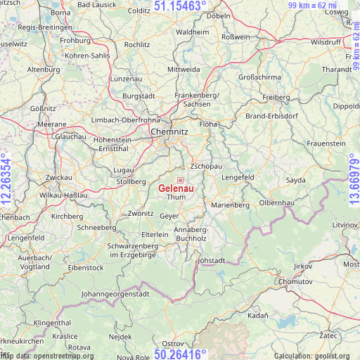
Gelenau GPS coordinates[2]
50° 42' 41.436" North, 12° 57' 59.976" East
| Map corner | latitude | longitude |
|---|---|---|
| Upper-left | 51.15463°, | 12.26354° |
| Center: | 50.71151°, | 12.96666° |
| Lower-right: | 50.26416°, | 13.66979° |
| Map W x H: | 99×99 km | = 61.5×61.5mi |
| max Lat: | 55.01917° ⇑47.6% North |
| Gelenau: | 50.71151° |
| min Lat: | ⇓52.4% South 47.40724° |
| min Long | Gelenau | max Long |
| 5.92978° | 12.96666° | 14.98853° |
| W 92%⇐ | ⇒8% E |
Elevation
Elevation of Gelenau is 460 m = 1509 ft, and this is 210.9 m = 692 ft above average elevation for this country.
| Max E: |
1256 m = 4121 ft | 16.2% |
| Gelenau | 460 m 1509 ft | |
| Avg. | 249.1 m = 817 ft | |
Min E: |
-5 m = -16 ft | 83.8% |
See also: Germany elevation on elevation.city.
Geographical zone
Gelenau is located in North temperate zone (between Tropic of Cancer and the Arctic Circle). Distance of this North polar circle is 1762.6 km =1095.2 mi to North.| Distance of | km | miles | from Gelenau |
|---|---|---|---|
| North Pole | 4368.5 | 2714.5 | to North |
| Arctic Circle | 1762.6 | 1095.2 | to North |
| Tropic Cancer | 3032.7 | 1884.4 | to South |
| Equator | 5638.6 | 3503.7 | to South |


Nearby cities:
15 places around Gelenau: (largest is in red/bold)
• Auerbach
4.7 km =2.9 mi,  228°
228°
• Burkhardtsdorf
4.3 km =2.7 mi,  304°
304°
• Drebach
5.3 km =3.3 mi,  138°
138°
• Ehrenfriedersdorf
6.9 km =4.3 mi,  177°
177°
• Gornau
7.3 km =4.5 mi,  43°
43°
• Gornsdorf
6 km =3.7 mi,  257°
257°
• Großolbersdorf
8.3 km =5.2 mi,  98°
98°
• Hormersdorf
7.3 km =4.5 mi,  235°
235°
• Jahnsdorf
8.8 km =5.5 mi, 295°
• Scharfenstein
6.4 km =4 mi, 97°
• Thalheim
8.3 km =5.2 mi, 261°
• Thum
4.7 km =2.9 mi,  193°
193°
• Venusberg
3.9 km =2.4 mi,  110°
110°
• Wolkenstein
9.7 km =6 mi,  130°
130°
• Zschopau
8.8 km =5.5 mi,  62°
62°
Sources, notices
• [Note1] Compared only with cities in Germany existing in our database
• [Src1] Map data: © OpenStreetMap contributors (CC-BY-SA)
• [Src2] Other city data from geonames.org with taken over terms of usage.
• [Src3] Geographical zone / Annual Mean Temperature by Robert A. Rohde @ Wikipedia
