Gornau geodata
Gornau (Saxony) is a populated place; located in Germany in Europe/Berlin (GMT+2) time zone. With population of 4,101 people, there are 3232 cities with bigger population in this country. Compared to other cities in Germany, 53.4% of cities are located further ↓South; 92.5% of cities are located further ←West and 81.9% of cities have lower elevation than Gornau. Note1


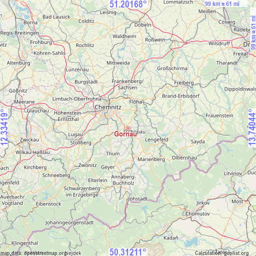
Gornau GPS coordinates[2]
50° 45' 32.436" North, 13° 2' 14.316" East
| Map corner | latitude | longitude |
|---|---|---|
| Upper-left | 51.20168°, | 12.33419° |
| Center: | 50.75901°, | 13.03731° |
| Lower-right: | 50.31211°, | 13.74044° |
| Map W x H: | 98.9×98.9 km | = 61.5×61.5mi |
| max Lat: | 55.01917° ⇑46.6% North |
| Gornau: | 50.75901° |
| min Lat: | ⇓53.4% South 47.40724° |
| min Long | Gornau | max Long |
| 5.92978° | 13.03731° | 14.98853° |
| W 92.5%⇐ | ⇒7.5% E |
Elevation
Elevation of Gornau is 445 m = 1460 ft, and this is 195.9 m = 643 ft above average elevation for this country.
| Max E: |
1256 m = 4121 ft | 18.1% |
| Gornau | 445 m 1460 ft | |
| Avg. | 249.1 m = 817 ft | |
Min E: |
-5 m = -16 ft | 81.9% |
See also: Germany elevation on elevation.city.
Geographical zone
Gornau is located in North temperate zone (between Tropic of Cancer and the Arctic Circle). Distance of this North polar circle is 1757.3 km =1091.9 mi to North.| Distance of | km | miles | from Gornau |
|---|---|---|---|
| North Pole | 4363.2 | 2711.2 | to North |
| Arctic Circle | 1757.3 | 1091.9 | to North |
| Tropic Cancer | 3038 | 1887.7 | to South |
| Equator | 5643.9 | 3507 | to South |


Nearby cities:
15 places around Gornau: (largest is in red/bold)
• Augustusburg
7.4 km =4.6 mi,  37°
37°
• Borstendorf
10.1 km =6.3 mi,  80°
80°
• Burkhardtsdorf
9 km =5.6 mi,  251°
251°
• Börnichen
7.3 km =4.5 mi,  97°
97°
• Chemnitz
11.4 km =7.1 mi,  318°
318°
• Drebach
9.4 km =5.8 mi,  189°
189°
• Flöha
11.1 km =6.9 mi,  13°
13°
• Gelenau
7.3 km =4.5 mi,  223°
223°
• Großolbersdorf
7.3 km =4.5 mi,  153°
153°
• Grünhainichen
8.2 km =5.1 mi, 83°
• Leubsdorf
10.2 km =6.3 mi,  63°
63°
• Scharfenstein
6.3 km =3.9 mi,  167°
167°
• Thum
11.5 km =7.1 mi,  211°
211°
• Venusberg
6.8 km =4.2 mi, 191°
• Zschopau
3 km =1.9 mi,  113°
113°
Sources, notices
• [Note1] Compared only with cities in Germany existing in our database
• [Src1] Map data: © OpenStreetMap contributors (CC-BY-SA)
• [Src2] Other city data from geonames.org with taken over terms of usage.
• [Src3] Geographical zone / Annual Mean Temperature by Robert A. Rohde @ Wikipedia
