Lengefeld geodata
Lengefeld (Saxony) is a populated place; located in Germany in Europe/Berlin (GMT+2) time zone. With population of 4,834 people, there are 2885 cities with bigger population in this country. Compared to other cities in Germany, 52.7% of cities are located further ↓South; 93.6% of cities are located further ←West and 87.2% of cities have lower elevation than Lengefeld. Note1


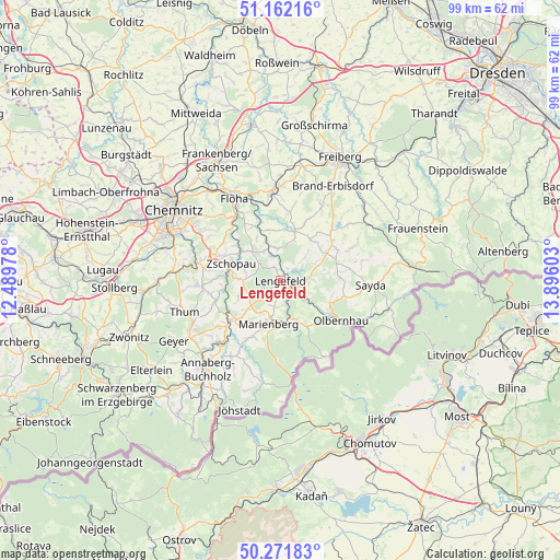
Lengefeld GPS coordinates[2]
50° 43' 8.796" North, 13° 11' 34.44" East
| Map corner | latitude | longitude |
|---|---|---|
| Upper-left | 51.16216°, | 12.48978° |
| Center: | 50.71911°, | 13.1929° |
| Lower-right: | 50.27183°, | 13.89603° |
| Map W x H: | 99×99 km | = 61.5×61.5mi |
| max Lat: | 55.01917° ⇑47.3% North |
| Lengefeld: | 50.71911° |
| min Lat: | ⇓52.7% South 47.40724° |
| min Long | Lengefeld | max Long |
| 5.92978° | 13.1929° | 14.98853° |
| W 93.6%⇐ | ⇒6.4% E |
Elevation
Elevation of Lengefeld is 487 m = 1598 ft, and this is 237.9 m = 781 ft above average elevation for this country.
| Max E: |
1256 m = 4121 ft | 12.8% |
| Lengefeld | 487 m 1598 ft | |
| Avg. | 249.1 m = 817 ft | |
Min E: |
-5 m = -16 ft | 87.2% |
See also: Germany elevation on elevation.city.
Geographical zone
Lengefeld is located in North temperate zone (between Tropic of Cancer and the Arctic Circle). Distance of this North polar circle is 1761.7 km =1094.7 mi to North.| Distance of | km | miles | from Lengefeld |
|---|---|---|---|
| North Pole | 4367.6 | 2713.9 | to North |
| Arctic Circle | 1761.7 | 1094.7 | to North |
| Tropic Cancer | 3033.5 | 1884.9 | to South |
| Equator | 5639.4 | 3504.2 | to South |


Nearby cities:
15 places around Lengefeld: (largest is in red/bold)
• Borstendorf
6.1 km =3.8 mi,  350°
350°
• Börnichen
5 km =3.1 mi,  313°
313°
• Eppendorf
9.4 km =5.8 mi,  17°
17°
• Großolbersdorf
8 km =5 mi,  254°
254°
• Großrückerswalde
10.9 km =6.8 mi,  209°
209°
• Grünhainichen
6 km =3.7 mi,  332°
332°
• Leubsdorf
9.2 km =5.7 mi, 348°
• Marienberg
7.9 km =4.9 mi,  196°
196°
• Pfaffroda
11.3 km =7 mi,  100°
100°
• Pobershau
8.9 km =5.5 mi,  168°
168°
• Pockau
3.6 km =2.2 mi,  126°
126°
• Scharfenstein
9.7 km =6 mi,  260°
260°
• Wolkenstein
11.1 km =6.9 mi,  230°
230°
• Zschopau
8.8 km =5.5 mi,  291°
291°
• Zöblitz
7.2 km =4.5 mi,  158°
158°
Sources, notices
• [Note1] Compared only with cities in Germany existing in our database
• [Src1] Map data: © OpenStreetMap contributors (CC-BY-SA)
• [Src2] Other city data from geonames.org with taken over terms of usage.
• [Src3] Geographical zone / Annual Mean Temperature by Robert A. Rohde @ Wikipedia
