Scharfenstein geodata
Scharfenstein (Saxony) is a populated place; located in Germany in Europe/Berlin (GMT+2) time zone. With population of 1,085 people, there are 6896 cities with bigger population in this country. Compared to other cities in Germany, 52.3% of cities are located further ↓South; 92.7% of cities are located further ←West and 72.8% of cities have lower elevation than Scharfenstein. Note1


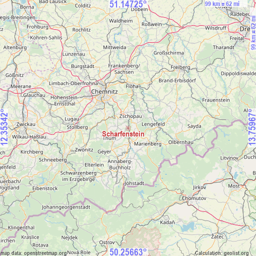
Scharfenstein GPS coordinates[2]
50° 42' 14.58" North, 13° 3' 23.544" East
| Map corner | latitude | longitude |
|---|---|---|
| Upper-left | 51.14725°, | 12.35342° |
| Center: | 50.70405°, | 13.05654° |
| Lower-right: | 50.25663°, | 13.75967° |
| Map W x H: | 99×99 km | = 61.5×61.5mi |
| max Lat: | 55.01917° ⇑47.7% North |
| Scharfenstein: | 50.70405° |
| min Lat: | ⇓52.3% South 47.40724° |
| min Long | Scharfenstein | max Long |
| 5.92978° | 13.05654° | 14.98853° |
| W 92.7%⇐ | ⇒7.3% E |
Elevation
Elevation of Scharfenstein is 380 m = 1247 ft, and this is 130.9 m = 429 ft above average elevation for this country.
| Max E: |
1256 m = 4121 ft | 27.2% |
| Scharfenstein | 380 m 1247 ft | |
| Avg. | 249.1 m = 817 ft | |
Min E: |
-5 m = -16 ft | 72.8% |
See also: Germany elevation on elevation.city.
Geographical zone
Scharfenstein is located in North temperate zone (between Tropic of Cancer and the Arctic Circle). Distance of this North polar circle is 1763.4 km =1095.7 mi to North.| Distance of | km | miles | from Scharfenstein |
|---|---|---|---|
| North Pole | 4369.3 | 2715 | to North |
| Arctic Circle | 1763.4 | 1095.7 | to North |
| Tropic Cancer | 3031.8 | 1883.9 | to South |
| Equator | 5637.8 | 3503.2 | to South |


Nearby cities:
15 places around Scharfenstein: (largest is in red/bold)
• Börnichen
7.8 km =4.8 mi,  49°
49°
• Drebach
4.2 km =2.6 mi,  222°
222°
• Ehrenfriedersdorf
8.6 km =5.3 mi,  225°
225°
• Gelenau
6.4 km =4 mi,  277°
277°
• Gornau
6.3 km =3.9 mi,  347°
347°
• Großolbersdorf
1.9 km =1.2 mi,  103°
103°
• Großrückerswalde
8.9 km =5.5 mi,  151°
151°
• Grünhainichen
9.8 km =6.1 mi,  44°
44°
• Lengefeld
9.7 km =6 mi,  80°
80°
• Marienberg
9.5 km =5.9 mi,  128°
128°
• Thermalbad Wiesenbad
9.7 km =6 mi,  182°
182°
• Thum
8.3 km =5.2 mi,  243°
243°
• Venusberg
2.7 km =1.7 mi,  258°
258°
• Wolkenstein
5.5 km =3.4 mi,  169°
169°
• Zschopau
5.1 km =3.2 mi,  16°
16°
Sources, notices
• [Note1] Compared only with cities in Germany existing in our database
• [Src1] Map data: © OpenStreetMap contributors (CC-BY-SA)
• [Src2] Other city data from geonames.org with taken over terms of usage.
• [Src3] Geographical zone / Annual Mean Temperature by Robert A. Rohde @ Wikipedia
