Zorge geodata
Zorge (Lower Saxony) is a seat of a fourth-order administrative division; located in Germany in Europe/Berlin (GMT+2) time zone. With population of 1,230 people, there are 6491 cities with bigger population in this country. Compared to other cities in Germany, 68.1% of cities are located further ↓South; 61.3% of cities are located further ←West and 73.3% of cities have lower elevation than Zorge. Note1


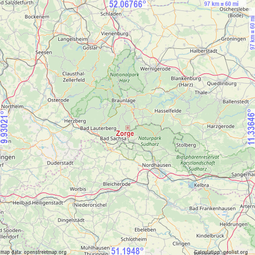
Zorge GPS coordinates[2]
51° 37' 59.988" North, 10° 37' 59.988" East
| Map corner | latitude | longitude |
|---|---|---|
| Upper-left | 52.06766°, | 9.93021° |
| Center: | 51.63333°, | 10.63333° |
| Lower-right: | 51.1948°, | 11.33646° |
| Map W x H: | 97.1×97.1 km | = 60.3×60.3mi |
| max Lat: | 55.01917° ⇑31.9% North |
| Zorge: | 51.63333° |
| min Lat: | ⇓68.1% South 47.40724° |
| min Long | Zorge | max Long |
| 5.92978° | 10.63333° | 14.98853° |
| W 61.3%⇐ | ⇒38.7% E |
Elevation
Elevation of Zorge is 385 m = 1263 ft, and this is 135.9 m = 446 ft above average elevation for this country.
| Max E: |
1256 m = 4121 ft | 26.7% |
| Zorge | 385 m 1263 ft | |
| Avg. | 249.1 m = 817 ft | |
Min E: |
-5 m = -16 ft | 73.3% |
See also: Germany elevation on elevation.city.
Geographical zone
Zorge is located in North temperate zone (between Tropic of Cancer and the Arctic Circle). Distance of this North polar circle is 1660.1 km =1031.5 mi to North.| Distance of | km | miles | from Zorge |
|---|---|---|---|
| North Pole | 4266 | 2650.8 | to North |
| Arctic Circle | 1660.1 | 1031.5 | to North |
| Tropic Cancer | 3135.2 | 1948.1 | to South |
| Equator | 5741.1 | 3567.4 | to South |


Nearby cities:
15 places around Zorge: (largest is in red/bold)
• Bad Lauterberg im Harz
11.3 km =7 mi,  269°
269°
• Bad Sachsa
6.9 km =4.3 mi,  231°
231°
• Benneckenstein
7 km =4.3 mi,  56°
56°
• Braunlage
10.5 km =6.5 mi,  351°
351°
• Elend
12.9 km =8 mi,  16°
16°
• Ellrich
5.6 km =3.5 mi,  158°
158°
• Etzelsrode
14.9 km =9.3 mi,  184°
184°
• Harzungen
14.8 km =9.2 mi,  125°
125°
• Ilfeld
12.3 km =7.6 mi,  121°
121°
• Niedersachswerfen
13 km =8.1 mi,  135°
135°
• Sankt Andreasberg
11.6 km =7.2 mi,  317°
317°
• Schierke
14.7 km =9.1 mi,  7°
7°
• Tanne
9.5 km =5.9 mi,  40°
40°
• Walkenried
5.7 km =3.5 mi,  191°
191°
• Wieda
3.2 km =2 mi, 271°
Sources, notices
• [Note1] Compared only with cities in Germany existing in our database
• [Src1] Map data: © OpenStreetMap contributors (CC-BY-SA)
• [Src2] Other city data from geonames.org with taken over terms of usage.
• [Src3] Geographical zone / Annual Mean Temperature by Robert A. Rohde @ Wikipedia
