Tanne geodata
Tanne (Saxony-Anhalt) is a populated place; located in Germany in Europe/Berlin (GMT+2) time zone. With population of 730 people, there are 8195 cities with bigger population in this country. Compared to other cities in Germany, 68.9% of cities are located further ↓South; 62.8% of cities are located further ←West and 87.3% of cities have lower elevation than Tanne. Note1
Administrative division(s):
- Level 1: Saxony-Anhalt
- Level 3: Landkreis Harz
- Level 4: Oberharz am Brocken


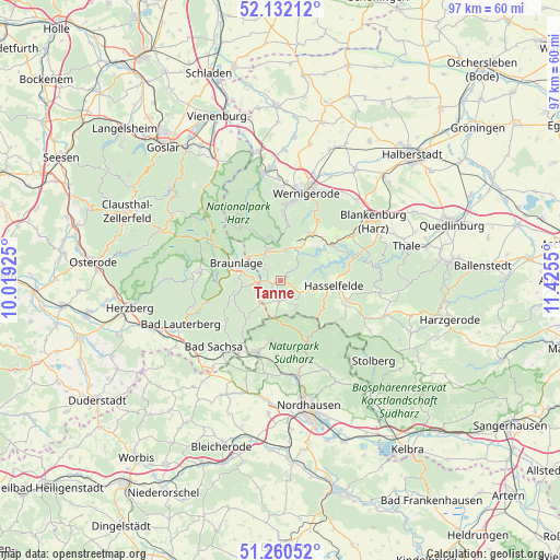
Tanne GPS coordinates[2]
51° 41' 54.312" North, 10° 43' 20.532" East
| Map corner | latitude | longitude |
|---|---|---|
| Upper-left | 52.13212°, | 10.01925° |
| Center: | 51.69842°, | 10.72237° |
| Lower-right: | 51.26052°, | 11.4255° |
| Map W x H: | 96.9×96.9 km | = 60.2×60.2mi |
| max Lat: | 55.01917° ⇑31.1% North |
| Tanne: | 51.69842° |
| min Lat: | ⇓68.9% South 47.40724° |
| min Long | Tanne | max Long |
| 5.92978° | 10.72237° | 14.98853° |
| W 62.8%⇐ | ⇒37.2% E |
Elevation
Elevation of Tanne is 488 m = 1601 ft, and this is 238.9 m = 784 ft above average elevation for this country.
| Max E: |
1256 m = 4121 ft | 12.7% |
| Tanne | 488 m 1601 ft | |
| Avg. | 249.1 m = 817 ft | |
Min E: |
-5 m = -16 ft | 87.3% |
See also: Germany elevation on elevation.city.
Geographical zone
Tanne is located in North temperate zone (between Tropic of Cancer and the Arctic Circle). Distance of this North polar circle is 1652.8 km =1027 mi to North.| Distance of | km | miles | from Tanne |
|---|---|---|---|
| North Pole | 4258.7 | 2646.2 | to North |
| Arctic Circle | 1652.8 | 1027 | to North |
| Tropic Cancer | 3142.4 | 1952.6 | to South |
| Equator | 5748.3 | 3571.8 | to South |


Nearby cities:
15 places around Tanne: (largest is in red/bold)
• Benneckenstein
3.4 km =2.1 mi,  186°
186°
• Braunlage
8.3 km =5.2 mi,  292°
292°
• Elbingerode
9.8 km =6.1 mi,  35°
35°
• Elend
5.7 km =3.5 mi,  335°
335°
• Ellrich
13.1 km =8.1 mi,  198°
198°
• Hasselfelde
9.1 km =5.7 mi,  95°
95°
• Hüttenrode
14.7 km =9.1 mi,  57°
57°
• Ilfeld
14.3 km =8.9 mi,  162°
162°
• Königshütte
5.8 km =3.6 mi,  30°
30°
• Rübeland
10.7 km =6.6 mi,  53°
53°
• Sankt Andreasberg
14.1 km =8.8 mi,  275°
275°
• Schierke
8.4 km =5.2 mi,  330°
330°
• Walkenried
14.7 km =9.1 mi,  209°
209°
• Wieda
11.8 km =7.3 mi,  232°
232°
• Zorge
9.5 km =5.9 mi,  220°
220°
Sources, notices
• [Note1] Compared only with cities in Germany existing in our database
• [Src1] Map data: © OpenStreetMap contributors (CC-BY-SA)
• [Src2] Other city data from geonames.org with taken over terms of usage.
• [Src3] Geographical zone / Annual Mean Temperature by Robert A. Rohde @ Wikipedia
