Bad Sachsa geodata
Bad Sachsa (Lower Saxony) is a populated place; located in Germany in Europe/Berlin (GMT+2) time zone. With population of 8,244 people, there are 1913 cities with bigger population in this country. Compared to other cities in Germany, 67.6% of cities are located further ↓South; 59.9% of cities are located further ←West and 64% of cities have lower elevation than Bad Sachsa. Note1


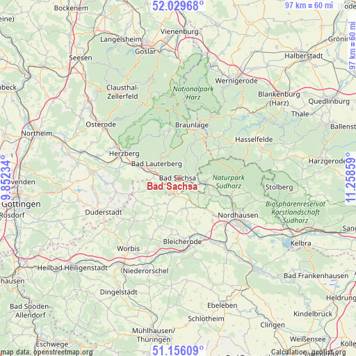
Bad Sachsa GPS coordinates[2]
51° 35' 41.964" North, 10° 33' 19.656" East
| Map corner | latitude | longitude |
|---|---|---|
| Upper-left | 52.02968°, | 9.85234° |
| Center: | 51.59499°, | 10.55546° |
| Lower-right: | 51.15609°, | 11.25859° |
| Map W x H: | 97.1×97.1 km | = 60.3×60.3mi |
| max Lat: | 55.01917° ⇑32.4% North |
| Bad Sachsa: | 51.59499° |
| min Lat: | ⇓67.6% South 47.40724° |
| min Long | Bad Sachsa | max Long |
| 5.92978° | 10.55546° | 14.98853° |
| W 59.9%⇐ | ⇒40.1% E |
Elevation
Elevation of Bad Sachsa is 315 m = 1033 ft, and this is 65.9 m = 216 ft above average elevation for this country.
| Max E: |
1256 m = 4121 ft | 36% |
| Bad Sachsa | 315 m 1033 ft | |
| Avg. | 249.1 m = 817 ft | |
Min E: |
-5 m = -16 ft | 64% |
See also: Germany elevation on elevation.city.
Geographical zone
Bad Sachsa is located in North temperate zone (between Tropic of Cancer and the Arctic Circle). Distance of this North polar circle is 1664.3 km =1034.1 mi to North.| Distance of | km | miles | from Bad Sachsa |
|---|---|---|---|
| North Pole | 4270.2 | 2653.4 | to North |
| Arctic Circle | 1664.3 | 1034.1 | to North |
| Tropic Cancer | 3130.9 | 1945.5 | to South |
| Equator | 5736.8 | 3564.7 | to South |


Nearby cities:
15 places around Bad Sachsa: (largest is in red/bold)
• Bad Lauterberg im Harz
7.2 km =4.5 mi,  305°
305°
• Benneckenstein
13.8 km =8.6 mi,  53°
53°
• Bischofferode
13.4 km =8.3 mi,  215°
215°
• Ellrich
7.5 km =4.7 mi,  97°
97°
• Etzelsrode
11.4 km =7.1 mi,  158°
158°
• Friedrichsthal
12.6 km =7.8 mi,  171°
171°
• Großbodungen
14.2 km =8.8 mi,  201°
201°
• Kehmstedt
14.1 km =8.8 mi, 164°
• Kleinbodungen
14.3 km =8.9 mi,  186°
186°
• Sankt Andreasberg
13 km =8.1 mi,  348°
348°
• Steinrode
11.2 km =7 mi, 202°
• Walkenried
4.4 km =2.7 mi,  107°
107°
• Weißenborn-Lüderode
11.8 km =7.3 mi,  233°
233°
• Wieda
4.9 km =3 mi,  26°
26°
• Zorge
6.9 km =4.3 mi, 51°
Sources, notices
• [Note1] Compared only with cities in Germany existing in our database
• [Src1] Map data: © OpenStreetMap contributors (CC-BY-SA)
• [Src2] Other city data from geonames.org with taken over terms of usage.
• [Src3] Geographical zone / Annual Mean Temperature by Robert A. Rohde @ Wikipedia
