Schierke geodata
Schierke (Saxony-Anhalt) is a populated place; located in Germany in Europe/Berlin (GMT+2) time zone. With population of 747 people, there are 8114 cities with bigger population in this country. Compared to other cities in Germany, 69.5% of cities are located further ↓South; 61.8% of cities are located further ←West and 95.6% of cities have lower elevation than Schierke. Note1


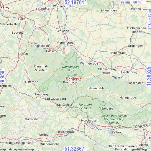
Schierke GPS coordinates[2]
51° 45' 50.184" North, 10° 39' 43.632" East
| Map corner | latitude | longitude |
|---|---|---|
| Upper-left | 52.19701°, | 9.959° |
| Center: | 51.76394°, | 10.66212° |
| Lower-right: | 51.32667°, | 11.36525° |
| Map W x H: | 96.8×96.8 km | = 60.1×60.1mi |
| max Lat: | 55.01917° ⇑30.5% North |
| Schierke: | 51.76394° |
| min Lat: | ⇓69.5% South 47.40724° |
| min Long | Schierke | max Long |
| 5.92978° | 10.66212° | 14.98853° |
| W 61.8%⇐ | ⇒38.2% E |
Elevation
Elevation of Schierke is 614 m = 2014 ft, and this is 364.9 m = 1197 ft above average elevation for this country.
| Max E: |
1256 m = 4121 ft | 4.4% |
| Schierke | 614 m 2014 ft | |
| Avg. | 249.1 m = 817 ft | |
Min E: |
-5 m = -16 ft | 95.6% |
See also: Germany elevation on elevation.city.
Geographical zone
Schierke is located in North temperate zone (between Tropic of Cancer and the Arctic Circle). Distance of this North polar circle is 1645.6 km =1022.5 mi to North.| Distance of | km | miles | from Schierke |
|---|---|---|---|
| North Pole | 4251.5 | 2641.8 | to North |
| Arctic Circle | 1645.6 | 1022.5 | to North |
| Tropic Cancer | 3149.7 | 1957.1 | to South |
| Equator | 5755.6 | 3576.4 | to South |


Nearby cities:
15 places around Schierke: (largest is in red/bold)
• Bad Harzburg
14.9 km =9.3 mi,  332°
332°
• Benneckenstein
11.3 km =7 mi,  160°
160°
• Braunlage
5.5 km =3.4 mi,  220°
220°
• Darlingerode
10.4 km =6.5 mi,  27°
27°
• Drübeck
11.2 km =7 mi,  20°
20°
• Elbingerode
9.9 km =6.2 mi,  85°
85°
• Elend
2.8 km =1.7 mi,  140°
140°
• Ilsenburg
11.5 km =7.1 mi,  5°
5°
• Königshütte
7.5 km =4.7 mi,  107°
107°
• Reddeber
15 km =9.3 mi,  40°
40°
• Rübeland
12.7 km =7.9 mi, 94°
• Sankt Andreasberg
11.6 km =7.2 mi,  238°
238°
• Tanne
8.4 km =5.2 mi,  150°
150°
• Wernigerode
11.5 km =7.1 mi,  45°
45°
• Zorge
14.7 km =9.1 mi,  187°
187°
Sources, notices
• [Note1] Compared only with cities in Germany existing in our database
• [Src1] Map data: © OpenStreetMap contributors (CC-BY-SA)
• [Src2] Other city data from geonames.org with taken over terms of usage.
• [Src3] Geographical zone / Annual Mean Temperature by Robert A. Rohde @ Wikipedia
