Ilfeld geodata
Ilfeld (Thuringia) is a populated place; located in Germany in Europe/Berlin (GMT+2) time zone. With population of 3,134 people, there are 3882 cities with bigger population in this country. Compared to other cities in Germany, 67.3% of cities are located further ↓South; 63.9% of cities are located further ←West and 53.6% of cities have lower elevation than Ilfeld. Note1


Ilfeld GPS coordinates[2]
51° 34' 32.52" North, 10° 47' 4.884" East
| Map corner | latitude | longitude |
|---|---|---|
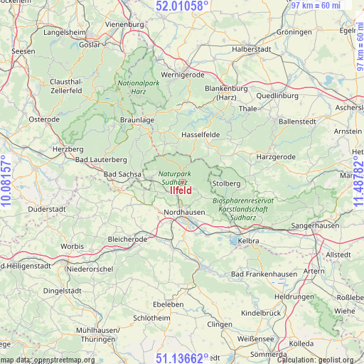
| Upper-left | 52.01058°, | 10.08157° |
| Center: | 51.5757°, | 10.78469° |
| Lower-right: | 51.13662°, | 11.48782° |
| Map W x H: | 97.2×97.2 km | = 60.4×60.4mi |
| max Lat: | 55.01917° ⇑32.7% North |
| Ilfeld: | 51.5757° |
| min Lat: | ⇓67.3% South 47.40724° |
| min Long | Ilfeld | max Long |
| 5.92978° | 10.78469° | 14.98853° |
| W 63.9%⇐ | ⇒36.1% E |
Elevation
Elevation of Ilfeld is 250 m = 820 ft, and this is 0.90000000000001 m = 3 ft above average elevation for this country.
| Max E: |
1256 m = 4121 ft | 46.4% |
| Ilfeld | 250 m 820 ft | |
| Avg. | 249.1 m = 817 ft | |
Min E: |
-5 m = -16 ft | 53.6% |
See also: Germany elevation on elevation.city.
Geographical zone
Ilfeld is located in North temperate zone (between Tropic of Cancer and the Arctic Circle). Distance of this North polar circle is 1666.5 km =1035.5 mi to North.| Distance of | km | miles | from Ilfeld |
|---|---|---|---|
| North Pole | 4272.4 | 2654.7 | to North |
| Arctic Circle | 1666.5 | 1035.5 | to North |
| Tropic Cancer | 3128.8 | 1944.1 | to South |
| Equator | 5734.7 | 3563.4 | to South |


Nearby cities:
15 places around Ilfeld: (largest is in red/bold)
• Benneckenstein
11.3 km =7 mi,  335°
335°
• Breitenstein
12.2 km =7.6 mi,  66°
66°
• Buchholz
7.4 km =4.6 mi,  129°
129°
• Ellrich
8.5 km =5.3 mi,  278°
278°
• Harzungen
2.7 km =1.7 mi,  145°
145°
• Hasselfelde
13.6 km =8.5 mi,  20°
20°
• Herrmannsacker
6.3 km =3.9 mi,  116°
116°
• Neustadt/Harz
3.5 km =2.2 mi,  106°
106°
• Niedersachswerfen
3.1 km =1.9 mi,  204°
204°
• Nordhausen
8.3 km =5.2 mi,  174°
174°
• Rottleberode
13 km =8.1 mi, 120°
• Stolberg
11.8 km =7.3 mi,  90°
90°
• Urbach
13.3 km =8.3 mi,  142°
142°
• Walkenried
11.6 km =7.2 mi,  274°
274°
• Zorge
12.3 km =7.6 mi,  301°
301°
Sources, notices
• [Note1] Compared only with cities in Germany existing in our database
• [Src1] Map data: © OpenStreetMap contributors (CC-BY-SA)
• [Src2] Other city data from geonames.org with taken over terms of usage.
• [Src3] Geographical zone / Annual Mean Temperature by Robert A. Rohde @ Wikipedia
