Elsterwerda geodata
Elsterwerda (Brandenburg) is a populated place; located in Germany in Europe/Berlin (GMT+2) time zone. With population of 9,694 people, there are 1671 cities with bigger population in this country. Compared to other cities in Germany, 65.7% of cities are located further ↓South; 95.9% of cities are located further ←West and 69.7% of cities have higher elevation than Elsterwerda. Note1
Administrative division(s):
- Level 1: Brandenburg
- Level 3: Landkreis Elbe-Elster
- Level 4: Elsterwerda


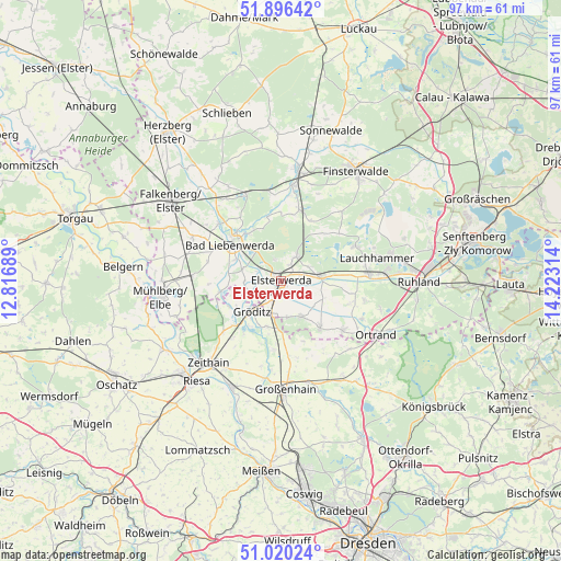
Elsterwerda GPS coordinates[2]
51° 27' 37.548" North, 13° 31' 12.036" East
| Map corner | latitude | longitude |
|---|---|---|
| Upper-left | 51.89642°, | 12.81689° |
| Center: | 51.46043°, | 13.52001° |
| Lower-right: | 51.02024°, | 14.22314° |
| Map W x H: | 97.4×97.4 km | = 60.5×60.5mi |
| max Lat: | 55.01917° ⇑34.3% North |
| Elsterwerda: | 51.46043° |
| min Lat: | ⇓65.7% South 47.40724° |
| min Long | Elsterwerda | max Long |
| 5.92978° | 13.52001° | 14.98853° |
| W 95.9%⇐ | ⇒4.1% E |
Elevation
Elevation of Elsterwerda is 93 m = 305 ft, and this is 156.1 m = 512 ft below average elevation for this country.
| Max E: |
1256 m = 4121 ft | 69.7% |
| Avg. | 249.1 m = 817 ft | |
| Elsterwerda | 93 m = 305 ft | |
Min E: |
-5 m = -16 ft | 30.3% |
See also: Germany elevation on elevation.city.
Geographical zone
Elsterwerda is located in North temperate zone (between Tropic of Cancer and the Arctic Circle). Distance of this North polar circle is 1679.3 km =1043.5 mi to North.| Distance of | km | miles | from Elsterwerda |
|---|---|---|---|
| North Pole | 4285.2 | 2662.7 | to North |
| Arctic Circle | 1679.3 | 1043.5 | to North |
| Tropic Cancer | 3115.9 | 1936.1 | to South |
| Equator | 5721.9 | 3555.4 | to South |


Nearby cities:
15 places around Elsterwerda: (largest is in red/bold)
• Bad Liebenwerda
10.8 km =6.7 mi,  306°
306°
• Großthiemig
13.3 km =8.3 mi,  130°
130°
• Gröden
7.5 km =4.7 mi,  154°
154°
• Hirschfeld
10.9 km =6.8 mi,  141°
141°
• Hohenleipisch
4.9 km =3 mi,  25°
25°
• Lindenau
16.2 km =10.1 mi,  114°
114°
• Merzdorf
6.8 km =4.2 mi,  172°
172°
• Nauwalde
9 km =5.6 mi,  238°
238°
• Plessa
6.7 km =4.2 mi,  84°
84°
• Rückersdorf
12.7 km =7.9 mi,  16°
16°
• Schraden
12.7 km =7.9 mi, 107°
• Schönborn
15.7 km =9.8 mi,  352°
352°
• Tettau
15.1 km =9.4 mi,  101°
101°
• Wülknitz
13.3 km =8.3 mi,  218°
218°
• Zabeltitz
12.2 km =7.6 mi,  185°
185°
Sources, notices
• [Note1] Compared only with cities in Germany existing in our database
• [Src1] Map data: © OpenStreetMap contributors (CC-BY-SA)
• [Src2] Other city data from geonames.org with taken over terms of usage.
• [Src3] Geographical zone / Annual Mean Temperature by Robert A. Rohde @ Wikipedia
