Kandel geodata
Kandel (Rheinland-Pfalz) is a populated place; located in Germany in Europe/Berlin (GMT+2) time zone. With population of 8,385 people, there are 1892 cities with bigger population in this country. Compared to other cities in Germany, 82% of cities are located further ↑North; 74.1% of cities are located further →East and 64.1% of cities have higher elevation than Kandel. Note1


Kandel GPS coordinates[2]
49° 4' 57.972" North, 8° 11' 49.92" East
| Map corner | latitude | longitude |
|---|---|---|
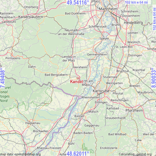
| Upper-left | 49.54116°, | 7.49408° |
| Center: | 49.08277°, | 8.1972° |
| Lower-right: | 48.62011°, | 8.90033° |
| Map W x H: | 102.4×102.4 km | = 63.6×63.6mi |
| max Lat: | 55.01917° ⇑82% North |
| Kandel: | 49.08277° |
| min Lat: | ⇓18% South 47.40724° |
| min Long | Kandel | max Long |
| 5.92978° | 8.1972° | 14.98853° |
| W 25.9%⇐ | ⇒74.1% E |
Elevation
Elevation of Kandel is 126 m = 413 ft, and this is 123.1 m = 404 ft below average elevation for this country.
| Max E: |
1256 m = 4121 ft | 64.1% |
| Avg. | 249.1 m = 817 ft | |
| Kandel | 126 m = 413 ft | |
Min E: |
-5 m = -16 ft | 35.9% |
See also: Germany elevation on elevation.city.
Geographical zone
Kandel is located in North temperate zone (between Tropic of Cancer and the Arctic Circle). Distance of this North polar circle is 1943.7 km =1207.8 mi to North.| Distance of | km | miles | from Kandel |
|---|---|---|---|
| North Pole | 4549.6 | 2827 | to North |
| Arctic Circle | 1943.7 | 1207.8 | to North |
| Tropic Cancer | 2851.6 | 1771.9 | to South |
| Equator | 5457.5 | 3391.1 | to South |


Nearby cities:
15 places around Kandel: (largest is in red/bold)
• Erlenbach
3.2 km =2 mi,  346°
346°
• Freckenfeld
6.4 km =4 mi,  251°
251°
• Hagenbach
8.2 km =5.1 mi,  152°
152°
• Hatzenbühl
4.7 km =2.9 mi,  48°
48°
• Hergersweiler
7.8 km =4.8 mi,  281°
281°
• Herxheim
7.2 km =4.5 mi,  9°
9°
• Herxheimweyher
8.8 km =5.5 mi,  28°
28°
• Jockgrim
5.8 km =3.6 mi,  78°
78°
• Minfeld
4 km =2.5 mi, 251°
• Rheinzabern
7.1 km =4.4 mi,  56°
56°
• Rohrbach
7.8 km =4.8 mi,  320°
320°
• Steinweiler
5.9 km =3.7 mi, 316°
• Vollmersweiler
9 km =5.6 mi,  257°
257°
• Winden
6.1 km =3.8 mi,  285°
285°
• Wörth am Rhein
5.9 km =3.7 mi,  129°
129°
Sources, notices
• [Note1] Compared only with cities in Germany existing in our database
• [Src1] Map data: © OpenStreetMap contributors (CC-BY-SA)
• [Src2] Other city data from geonames.org with taken over terms of usage.
• [Src3] Geographical zone / Annual Mean Temperature by Robert A. Rohde @ Wikipedia
