Willich geodata
Willich (North Rhine-Westphalia) is a populated place; located in Germany in Europe/Berlin (GMT+2) time zone. With population of 51,843 people, there are 212 cities with bigger population in this country. Compared to other cities in Germany, 62.6% of cities are located further ↓South; 97.5% of cities are located further →East and 81.4% of cities have higher elevation than Willich. Note1
Administrative division(s):
- Level 1: North Rhine-Westphalia
- Level 2: Düsseldorf District
- Level 3: Kreis Viersen
- Level 4: Willich


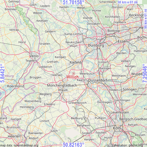
Willich GPS coordinates[2]
51° 15' 49.356" North, 6° 32' 50.424" East
| Map corner | latitude | longitude |
|---|---|---|
| Upper-left | 51.70158°, | 5.84421° |
| Center: | 51.26371°, | 6.54734° |
| Lower-right: | 50.82163°, | 7.25046° |
| Map W x H: | 97.8×97.8 km | = 60.8×60.8mi |
| max Lat: | 55.01917° ⇑37.4% North |
| Willich: | 51.26371° |
| min Lat: | ⇓62.6% South 47.40724° |
| min Long | Willich | max Long |
| 5.92978° | 6.54734° | 14.98853° |
| W 2.5%⇐ | ⇒97.5% E |
Elevation
Elevation of Willich is 43 m = 141 ft, and this is 206.1 m = 676 ft below average elevation for this country.
| Max E: |
1256 m = 4121 ft | 81.4% |
| Avg. | 249.1 m = 817 ft | |
| Willich | 43 m = 141 ft | |
Min E: |
-5 m = -16 ft | 18.6% |
See also: Willich elevation on elevation.city.
Geographical zone
Willich is located in North temperate zone (between Tropic of Cancer and the Arctic Circle). Distance of this North polar circle is 1701.2 km =1057.1 mi to North.| Distance of | km | miles | from Willich |
|---|---|---|---|
| North Pole | 4307.1 | 2676.3 | to North |
| Arctic Circle | 1701.2 | 1057.1 | to North |
| Tropic Cancer | 3094.1 | 1922.6 | to South |
| Equator | 5700 | 3541.8 | to South |


Nearby cities:
15 places around Willich: (largest is in red/bold)
• Düsseldorf
16.6 km =10.3 mi,  106°
106°
• Düsseldorf-Pempelfort
16.9 km =10.5 mi,  99°
99°
• Grefrath
16.5 km =10.3 mi,  299°
299°
• Jüchen
18.5 km =11.5 mi,  190°
190°
• Kaarst
6.3 km =3.9 mi,  127°
127°
• Kempen
14.3 km =8.9 mi,  321°
321°
• Korschenbroich
8.4 km =5.2 mi,  196°
196°
• Krefeld
8.1 km =5 mi,  3°
3°
• Meerbusch
9.9 km =6.2 mi, 97°
• Mönchengladbach
11.4 km =7.1 mi,  220°
220°
• Nettetal
19.3 km =12 mi,  287°
287°
• Neubrück
15.7 km =9.8 mi,  156°
156°
• Neuss
12 km =7.5 mi, 127°
• Tönisvorst
7.4 km =4.6 mi,  329°
329°
• Viersen
10.7 km =6.6 mi,  264°
264°
Sources, notices
• [Note1] Compared only with cities in Germany existing in our database
• [Src1] Map data: © OpenStreetMap contributors (CC-BY-SA)
• [Src2] Other city data from geonames.org with taken over terms of usage.
• [Src3] Geographical zone / Annual Mean Temperature by Robert A. Rohde @ Wikipedia
