Viersen geodata
Viersen (North Rhine-Westphalia) is a seat of a third-order administrative division; located in Germany in Europe/Berlin (GMT+2) time zone. With population of 76,153 people, there are 135 cities with bigger population in this country. Compared to other cities in Germany, 62.4% of cities are located further ↓South; 98.6% of cities are located further →East and 81% of cities have higher elevation than Viersen. Note1
Administrative division(s):
- Level 1: North Rhine-Westphalia
- Level 2: Düsseldorf District
- Level 3: Kreis Viersen
- Level 4: Viersen


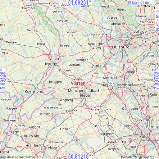
Viersen GPS coordinates[2]
51° 15' 15.66" North, 6° 23' 39.876" East
| Map corner | latitude | longitude |
|---|---|---|
| Upper-left | 51.69231°, | 5.69128° |
| Center: | 51.25435°, | 6.39441° |
| Lower-right: | 50.81218°, | 7.09753° |
| Map W x H: | 97.9×97.9 km | = 60.8×60.8mi |
| max Lat: | 55.01917° ⇑37.6% North |
| Viersen: | 51.25435° |
| min Lat: | ⇓62.4% South 47.40724° |
| min Long | Viersen | max Long |
| 5.92978° | 6.39441° | 14.98853° |
| W 1.4%⇐ | ⇒98.6% E |
Elevation
Elevation of Viersen is 44 m = 144 ft, and this is 205.1 m = 673 ft below average elevation for this country.
| Max E: |
1256 m = 4121 ft | 81% |
| Avg. | 249.1 m = 817 ft | |
| Viersen | 44 m = 144 ft | |
Min E: |
-5 m = -16 ft | 19% |
See also: Viersen elevation on elevation.city.
Geographical zone
Viersen is located in North temperate zone (between Tropic of Cancer and the Arctic Circle). Distance of this North polar circle is 1702.2 km =1057.7 mi to North.| Distance of | km | miles | from Viersen |
|---|---|---|---|
| North Pole | 4308.1 | 2676.9 | to North |
| Arctic Circle | 1702.2 | 1057.7 | to North |
| Tropic Cancer | 3093 | 1921.9 | to South |
| Equator | 5698.9 | 3541.1 | to South |


Nearby cities:
15 places around Viersen: (largest is in red/bold)
• Brüggen
14.7 km =9.1 mi,  264°
264°
• Grefrath
9.8 km =6.1 mi,  337°
337°
• Jüchen
18.7 km =11.6 mi,  156°
156°
• Kaarst
15.9 km =9.9 mi,  100°
100°
• Kempen
12.3 km =7.6 mi,  7°
7°
• Korschenbroich
10.9 km =6.8 mi,  130°
130°
• Krefeld
14.4 km =8.9 mi,  50°
50°
• Mönchengladbach
8.3 km =5.2 mi, 156°
• Nettetal
10.4 km =6.5 mi,  311°
311°
• Niederkrüchten
13.8 km =8.6 mi,  243°
243°
• Schwalmtal
9.8 km =6.1 mi, 244°
• Tönisvorst
10.1 km =6.3 mi,  43°
43°
• Wachtendonk
17.6 km =10.9 mi,  347°
347°
• Wegberg
14.6 km =9.1 mi,  211°
211°
• Willich
10.7 km =6.6 mi,  84°
84°
Sources, notices
• [Note1] Compared only with cities in Germany existing in our database
• [Src1] Map data: © OpenStreetMap contributors (CC-BY-SA)
• [Src2] Other city data from geonames.org with taken over terms of usage.
• [Src3] Geographical zone / Annual Mean Temperature by Robert A. Rohde @ Wikipedia
