Tönisvorst geodata
Tönisvorst (North Rhine-Westphalia) is a populated place; located in Germany in Europe/Berlin (GMT+2) time zone. With population of 30,296 people, there are 457 cities with bigger population in this country. Compared to other cities in Germany, 63.6% of cities are located further ↓South; 97.8% of cities are located further →East and 82% of cities have higher elevation than Tönisvorst. Note1
Administrative division(s):
- Level 1: North Rhine-Westphalia
- Level 2: Düsseldorf District
- Level 3: Kreis Viersen
- Level 4: Tönisvorst


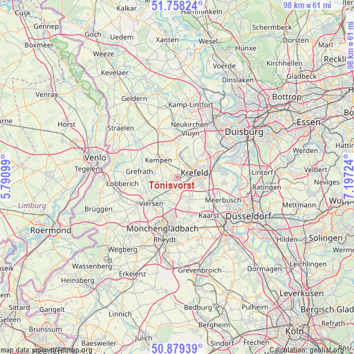
Tönisvorst GPS coordinates[2]
51° 19' 15.312" North, 6° 29' 38.832" East
| Map corner | latitude | longitude |
|---|---|---|
| Upper-left | 51.75824°, | 5.79099° |
| Center: | 51.32092°, | 6.49412° |
| Lower-right: | 50.87939°, | 7.19724° |
| Map W x H: | 97.7×97.7 km | = 60.7×60.7mi |
| max Lat: | 55.01917° ⇑36.4% North |
| Tönisvorst: | 51.32092° |
| min Lat: | ⇓63.6% South 47.40724° |
| min Long | Tönisvorst | max Long |
| 5.92978° | 6.49412° | 14.98853° |
| W 2.2%⇐ | ⇒97.8% E |
Elevation
Elevation of Tönisvorst is 42 m = 138 ft, and this is 207.1 m = 679 ft below average elevation for this country.
| Max E: |
1256 m = 4121 ft | 82% |
| Avg. | 249.1 m = 817 ft | |
| Tönisvorst | 42 m = 138 ft | |
Min E: |
-5 m = -16 ft | 18% |
See also: Germany elevation on elevation.city.
Geographical zone
Tönisvorst is located in North temperate zone (between Tropic of Cancer and the Arctic Circle). Distance of this North polar circle is 1694.8 km =1053.1 mi to North.| Distance of | km | miles | from Tönisvorst |
|---|---|---|---|
| North Pole | 4300.7 | 2672.3 | to North |
| Arctic Circle | 1694.8 | 1053.1 | to North |
| Tropic Cancer | 3100.4 | 1926.5 | to South |
| Equator | 5706.4 | 3545.8 | to South |


Nearby cities:
15 places around Tönisvorst: (largest is in red/bold)
• Grefrath
10.8 km =6.7 mi,  279°
279°
• Kaarst
13.4 km =8.3 mi,  139°
139°
• Kempen
7.1 km =4.4 mi,  312°
312°
• Korschenbroich
14.5 km =9 mi,  174°
174°
• Krefeld
4.5 km =2.8 mi,  67°
67°
• Meerbusch
15.5 km =9.6 mi,  119°
119°
• Moers
17.6 km =10.9 mi,  33°
33°
• Mönchengladbach
15.5 km =9.6 mi,  193°
193°
• Nettetal
14.7 km =9.1 mi,  268°
268°
• Neuss
19.1 km =11.9 mi, 135°
• Rheurdt
16.3 km =10.1 mi,  353°
353°
• Schwalmtal
19.6 km =12.2 mi,  233°
233°
• Viersen
10.1 km =6.3 mi,  223°
223°
• Wachtendonk
14.6 km =9.1 mi, 312°
• Willich
7.4 km =4.6 mi,  149°
149°
Sources, notices
• [Note1] Compared only with cities in Germany existing in our database
• [Src1] Map data: © OpenStreetMap contributors (CC-BY-SA)
• [Src2] Other city data from geonames.org with taken over terms of usage.
• [Src3] Geographical zone / Annual Mean Temperature by Robert A. Rohde @ Wikipedia
