Mönchengladbach geodata
Mönchengladbach (North Rhine-Westphalia) is a seat of a third-order administrative division; located in Germany in Europe/Berlin (GMT+2) time zone. With population of 261,742 people, there are 29 cities with bigger population in this country. Compared to other cities in Germany, 61.3% of cities are located further ↓South; 98.2% of cities are located further →East and 76.7% of cities have higher elevation than Mönchengladbach. Note1
Administrative division(s):
- Level 1: North Rhine-Westphalia
- Level 2: Düsseldorf District
- Level 3: Kreisfreie Stadt Mönchengladbach
- Level 4: Mönchengladbach


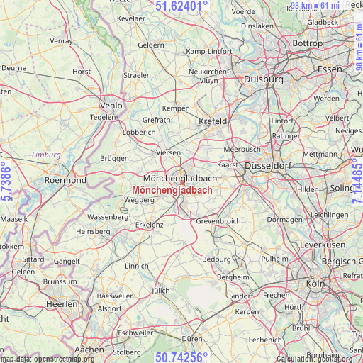
Mönchengladbach GPS coordinates[2]
51° 11' 7.404" North, 6° 26' 30.192" East
| Map corner | latitude | longitude |
|---|---|---|
| Upper-left | 51.62401°, | 5.7386° |
| Center: | 51.18539°, | 6.44172° |
| Lower-right: | 50.74256°, | 7.14485° |
| Map W x H: | 98×98 km | = 60.9×60.9mi |
| max Lat: | 55.01917° ⇑38.7% North |
| Mönchengladbach: | 51.18539° |
| min Lat: | ⇓61.3% South 47.40724° |
| min Long | Mönchengladbac | max Long |
| 5.92978° | 6.44172° | 14.98853° |
| W 1.8%⇐ | ⇒98.2% E |
Elevation
Elevation of Mönchengladbach is 57 m = 187 ft, and this is 192.1 m = 630 ft below average elevation for this country.
| Max E: |
1256 m = 4121 ft | 76.7% |
| Avg. | 249.1 m = 817 ft | |
| Mönchengladbach | 57 m = 187 ft | |
Min E: |
-5 m = -16 ft | 23.3% |
See also: Mönchengladbach elevation on elevation.city.
Geographical zone
Mönchengladbach is located in North temperate zone (between Tropic of Cancer and the Arctic Circle). Distance of this North polar circle is 1709.9 km =1062.5 mi to North.| Distance of | km | miles | from Mönchengladbach |
|---|---|---|---|
| North Pole | 4315.8 | 2681.7 | to North |
| Arctic Circle | 1709.9 | 1062.5 | to North |
| Tropic Cancer | 3085.4 | 1917.2 | to South |
| Equator | 5691.3 | 3536.4 | to South |


Nearby cities:
15 places around Mönchengladbach: (largest is in red/bold)
• Erkelenz
14.7 km =9.1 mi,  216°
216°
• Grefrath
18.2 km =11.3 mi,  337°
337°
• Grevenbroich
14.4 km =8.9 mi,  136°
136°
• Jüchen
10.3 km =6.4 mi,  156°
156°
• Kaarst
13.3 km =8.3 mi,  68°
68°
• Korschenbroich
5 km =3.1 mi,  82°
82°
• Nettetal
18.3 km =11.4 mi,  322°
322°
• Neubrück
14.9 km =9.3 mi,  112°
112°
• Neuss
17 km =10.6 mi,  85°
85°
• Niederkrüchten
15.8 km =9.8 mi,  275°
275°
• Schwalmtal
12.7 km =7.9 mi,  285°
285°
• Tönisvorst
15.5 km =9.6 mi,  13°
13°
• Viersen
8.3 km =5.2 mi, 336°
• Wegberg
12 km =7.5 mi,  246°
246°
• Willich
11.4 km =7.1 mi,  40°
40°
Sources, notices
• [Note1] Compared only with cities in Germany existing in our database
• [Src1] Map data: © OpenStreetMap contributors (CC-BY-SA)
• [Src2] Other city data from geonames.org with taken over terms of usage.
• [Src3] Geographical zone / Annual Mean Temperature by Robert A. Rohde @ Wikipedia
