Wilhelmsfeld geodata
Wilhelmsfeld (Baden-Württemberg) is a seat of a fourth-order administrative division; located in Germany in Europe/Berlin (GMT+2) time zone. With population of 3,433 people, there are 3667 cities with bigger population in this country. Compared to other cities in Germany, 76.2% of cities are located further ↑North; 68.5% of cities are located further →East and 81% of cities have lower elevation than Wilhelmsfeld. Note1
Administrative division(s):
- Level 1: Baden-Württemberg
- Level 2: Karlsruhe Region
- Level 3: Rhein-Neckar-Kreis
- Level 4: Wilhelmsfeld


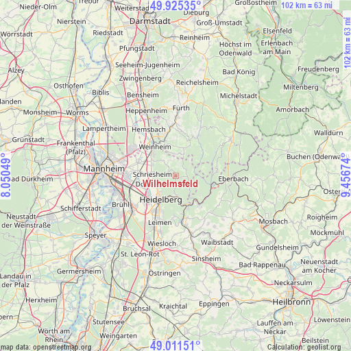
Wilhelmsfeld GPS coordinates[2]
49° 28' 14.016" North, 8° 45' 12.996" East
| Map corner | latitude | longitude |
|---|---|---|
| Upper-left | 49.92535°, | 8.05049° |
| Center: | 49.47056°, | 8.75361° |
| Lower-right: | 49.01151°, | 9.45674° |
| Map W x H: | 101.6×101.6 km | = 63.1×63.1mi |
| max Lat: | 55.01917° ⇑76.2% North |
| Wilhelmsfeld: | 49.47056° |
| min Lat: | ⇓23.8% South 47.40724° |
| min Long | Wilhelmsfeld | max Long |
| 5.92978° | 8.75361° | 14.98853° |
| W 31.5%⇐ | ⇒68.5% E |
Elevation
Elevation of Wilhelmsfeld is 440 m = 1444 ft, and this is 190.9 m = 626 ft above average elevation for this country.
| Max E: |
1256 m = 4121 ft | 19% |
| Wilhelmsfeld | 440 m 1444 ft | |
| Avg. | 249.1 m = 817 ft | |
Min E: |
-5 m = -16 ft | 81% |
See also: Germany elevation on elevation.city.
Geographical zone
Wilhelmsfeld is located in North temperate zone (between Tropic of Cancer and the Arctic Circle). Distance of this North polar circle is 1900.6 km =1181 mi to North.| Distance of | km | miles | from Wilhelmsfeld |
|---|---|---|---|
| North Pole | 4506.5 | 2800.2 | to North |
| Arctic Circle | 1900.6 | 1181 | to North |
| Tropic Cancer | 2894.7 | 1798.7 | to South |
| Equator | 5500.6 | 3417.9 | to South |


Nearby cities:
15 places around Wilhelmsfeld: (largest is in red/bold)
• Birkenau
10.8 km =6.7 mi,  341°
341°
• Dossenheim
6.1 km =3.8 mi,  248°
248°
• Edingen-Neckarhausen
10.7 km =6.6 mi,  262°
262°
• Heddesbach
5.5 km =3.4 mi,  78°
78°
• Heidelberg
8.3 km =5.2 mi,  213°
213°
• Heiligkreuzsteinach
3.3 km =2.1 mi,  64°
64°
• Hirschberg an der Bergstraße
8.1 km =5 mi,  300°
300°
• Hirschhorn
10.7 km =6.6 mi,  105°
105°
• Ladenburg
10.5 km =6.5 mi,  271°
271°
• Neckargemünd
9.6 km =6 mi,  161°
161°
• Neckarsteinach
9.6 km =6 mi,  137°
137°
• Schriesheim
6.5 km =4 mi, 273°
• Schönau
5.5 km =3.4 mi,  133°
133°
• Unter-Abtsteinach
6.7 km =4.2 mi,  20°
20°
• Weinheim
10.7 km =6.6 mi,  324°
324°
Sources, notices
• [Note1] Compared only with cities in Germany existing in our database
• [Src1] Map data: © OpenStreetMap contributors (CC-BY-SA)
• [Src2] Other city data from geonames.org with taken over terms of usage.
• [Src3] Geographical zone / Annual Mean Temperature by Robert A. Rohde @ Wikipedia
