Heddesbach geodata
Heddesbach (Baden-Württemberg) is a seat of a fourth-order administrative division; located in Germany in Europe/Berlin (GMT+2) time zone. With population of 518 people, there are 9265 cities with bigger population in this country. Compared to other cities in Germany, 76.1% of cities are located further ↑North; 67.6% of cities are located further →East and 53.7% of cities have higher elevation than Heddesbach. Note1
Administrative division(s):
- Level 1: Baden-Württemberg
- Level 2: Karlsruhe Region
- Level 3: Rhein-Neckar-Kreis
- Level 4: Heddesbach


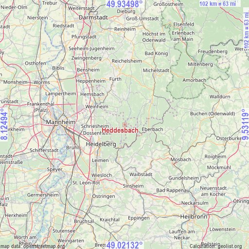
Heddesbach GPS coordinates[2]
49° 28' 49.008" North, 8° 49' 41.016" East
| Map corner | latitude | longitude |
|---|---|---|
| Upper-left | 49.93498°, | 8.12494° |
| Center: | 49.48028°, | 8.82806° |
| Lower-right: | 49.02132°, | 9.53119° |
| Map W x H: | 101.6×101.6 km | = 63.1×63.1mi |
| max Lat: | 55.01917° ⇑76.1% North |
| Heddesbach: | 49.48028° |
| min Lat: | ⇓23.9% South 47.40724° |
| min Long | Heddesbach | max Long |
| 5.92978° | 8.82806° | 14.98853° |
| W 32.4%⇐ | ⇒67.6% E |
Elevation
Elevation of Heddesbach is 199 m = 653 ft, and this is 50.1 m = 164 ft below average elevation for this country.
| Max E: |
1256 m = 4121 ft | 53.7% |
| Avg. | 249.1 m = 817 ft | |
| Heddesbach | 199 m = 653 ft | |
Min E: |
-5 m = -16 ft | 46.3% |
See also: Germany elevation on elevation.city.
Geographical zone
Heddesbach is located in North temperate zone (between Tropic of Cancer and the Arctic Circle). Distance of this North polar circle is 1899.5 km =1180.3 mi to North.| Distance of | km | miles | from Heddesbach |
|---|---|---|---|
| North Pole | 4505.4 | 2799.5 | to North |
| Arctic Circle | 1899.5 | 1180.3 | to North |
| Tropic Cancer | 2895.8 | 1799.4 | to South |
| Equator | 5501.7 | 3418.6 | to South |


Nearby cities:
15 places around Heddesbach: (largest is in red/bold)
• Birkenau
12.6 km =7.8 mi,  316°
316°
• Dossenheim
11.6 km =7.2 mi,  253°
253°
• Eberbach
11.8 km =7.3 mi,  97°
97°
• Heiligkreuzsteinach
2.4 km =1.5 mi,  278°
278°
• Hirschberg an der Bergstraße
12.7 km =7.9 mi, 283°
• Hirschhorn
6.2 km =3.9 mi,  128°
128°
• Lobbach
12.5 km =7.8 mi,  159°
159°
• Neckargemünd
10.4 km =6.5 mi,  192°
192°
• Neckarsteinach
8.2 km =5.1 mi,  172°
172°
• Rothenberg
6.9 km =4.3 mi,  72°
72°
• Schriesheim
11.9 km =7.4 mi,  266°
266°
• Schönau
5 km =3.1 mi,  196°
196°
• Unter-Abtsteinach
6 km =3.7 mi,  330°
330°
• Wald-Michelbach
10 km =6.2 mi,  1°
1°
• Wilhelmsfeld
5.5 km =3.4 mi,  258°
258°
Sources, notices
• [Note1] Compared only with cities in Germany existing in our database
• [Src1] Map data: © OpenStreetMap contributors (CC-BY-SA)
• [Src2] Other city data from geonames.org with taken over terms of usage.
• [Src3] Geographical zone / Annual Mean Temperature by Robert A. Rohde @ Wikipedia
