Hirschhorn geodata
Hirschhorn (Hesse) is a populated place; located in Germany in Europe/Berlin (GMT+2) time zone. With population of 3,691 people, there are 3483 cities with bigger population in this country. Compared to other cities in Germany, 76.6% of cities are located further ↑North; 66.7% of cities are located further →East and 63.3% of cities have higher elevation than Hirschhorn. Note1
Administrative division(s):
- Level 1: Hesse
- Level 2: Regierungsbezirk Darmstadt
- Level 3: Landkreis Bergstraße
- Level 4: Hirschhorn (Neckar)


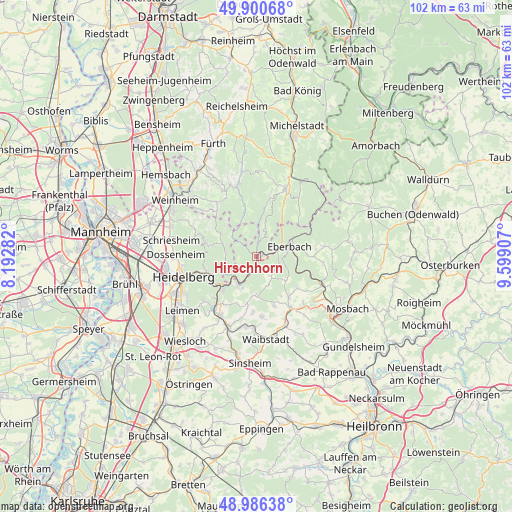
Hirschhorn GPS coordinates[2]
49° 26' 44.376" North, 8° 53' 45.384" East
| Map corner | latitude | longitude |
|---|---|---|
| Upper-left | 49.90068°, | 8.19282° |
| Center: | 49.44566°, | 8.89594° |
| Lower-right: | 48.98638°, | 9.59907° |
| Map W x H: | 101.7×101.7 km | = 63.2×63.2mi |
| max Lat: | 55.01917° ⇑76.6% North |
| Hirschhorn: | 49.44566° |
| min Lat: | ⇓23.4% South 47.40724° |
| min Long | Hirschhorn | max Long |
| 5.92978° | 8.89594° | 14.98853° |
| W 33.3%⇐ | ⇒66.7% E |
Elevation
Elevation of Hirschhorn is 130 m = 427 ft, and this is 119.1 m = 391 ft below average elevation for this country.
| Max E: |
1256 m = 4121 ft | 63.3% |
| Avg. | 249.1 m = 817 ft | |
| Hirschhorn | 130 m = 427 ft | |
Min E: |
-5 m = -16 ft | 36.7% |
See also: Germany elevation on elevation.city.
Geographical zone
Hirschhorn is located in North temperate zone (between Tropic of Cancer and the Arctic Circle). Distance of this North polar circle is 1903.3 km =1182.7 mi to North.| Distance of | km | miles | from Hirschhorn |
|---|---|---|---|
| North Pole | 4509.2 | 2801.9 | to North |
| Arctic Circle | 1903.3 | 1182.7 | to North |
| Tropic Cancer | 2891.9 | 1796.9 | to South |
| Equator | 5497.8 | 3416.2 | to South |


Nearby cities:
15 places around Hirschhorn: (largest is in red/bold)
• Aglasterhausen
11.9 km =7.4 mi,  146°
146°
• Eberbach
7.2 km =4.5 mi,  70°
70°
• Heddesbach
6.2 km =3.9 mi,  308°
308°
• Heiligkreuzsteinach
8.4 km =5.2 mi,  299°
299°
• Lobbach
7.9 km =4.9 mi,  183°
183°
• Neckargemünd
9.6 km =6 mi,  228°
228°
• Neckarsteinach
5.7 km =3.5 mi,  221°
221°
• Neunkirchen
10.6 km =6.6 mi,  128°
128°
• Reichartshausen
10.7 km =6.6 mi,  160°
160°
• Rothenberg
6.2 km =3.9 mi,  15°
15°
• Schönau
6.4 km =4 mi,  260°
260°
• Spechbach
11.1 km =6.9 mi, 184°
• Wiesenbach
11.5 km =7.1 mi, 215°
• Wilhelmsfeld
10.7 km =6.6 mi,  285°
285°
• Zwingenberg
10.9 km =6.8 mi,  105°
105°
Sources, notices
• [Note1] Compared only with cities in Germany existing in our database
• [Src1] Map data: © OpenStreetMap contributors (CC-BY-SA)
• [Src2] Other city data from geonames.org with taken over terms of usage.
• [Src3] Geographical zone / Annual Mean Temperature by Robert A. Rohde @ Wikipedia
