Wiesthal geodata
Wiesthal (Bavaria) is a seat of a fourth-order administrative division; located in Germany in Europe/Berlin (GMT+2) time zone. With population of 1,445 people, there are 5987 cities with bigger population in this country. Compared to other cities in Germany, 63% of cities are located further ↑North; 58.8% of cities are located further →East and 57.3% of cities have lower elevation than Wiesthal. Note1
Administrative division(s):
- Level 1: Bavaria
- Level 2: Regierungsbezirk Unterfranken
- Level 3: Landkreis Main-Spessart
- Level 4: Wiesthal


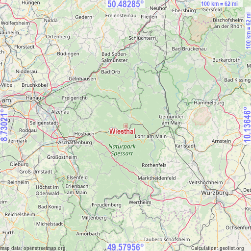
Wiesthal GPS coordinates[2]
50° 1' 59.988" North, 9° 25' 59.988" East
| Map corner | latitude | longitude |
|---|---|---|
| Upper-left | 50.48285°, | 8.73021° |
| Center: | 50.03333°, | 9.43333° |
| Lower-right: | 49.57956°, | 10.13646° |
| Map W x H: | 100.4×100.4 km | = 62.4×62.4mi |
| max Lat: | 55.01917° ⇑63% North |
| Wiesthal: | 50.03333° |
| min Lat: | ⇓37% South 47.40724° |
| min Long | Wiesthal | max Long |
| 5.92978° | 9.43333° | 14.98853° |
| W 41.2%⇐ | ⇒58.8% E |
Elevation
Elevation of Wiesthal is 274 m = 899 ft, and this is 24.9 m = 82 ft above average elevation for this country.
| Max E: |
1256 m = 4121 ft | 42.7% |
| Wiesthal | 274 m 899 ft | |
| Avg. | 249.1 m = 817 ft | |
Min E: |
-5 m = -16 ft | 57.3% |
See also: Germany elevation on elevation.city.
Geographical zone
Wiesthal is located in North temperate zone (between Tropic of Cancer and the Arctic Circle). Distance of this North polar circle is 1838 km =1142.1 mi to North.| Distance of | km | miles | from Wiesthal |
|---|---|---|---|
| North Pole | 4443.9 | 2761.3 | to North |
| Arctic Circle | 1838 | 1142.1 | to North |
| Tropic Cancer | 2957.3 | 1837.6 | to South |
| Equator | 5563.2 | 3456.8 | to South |


Nearby cities:
15 places around Wiesthal: (largest is in red/bold)
• Frammersbach
4.3 km =2.7 mi,  36°
36°
• Heigenbrücken
4.5 km =2.8 mi,  262°
262°
• Heinrichsthal
7.7 km =4.8 mi,  303°
303°
• Laufach
9.7 km =6 mi, 258°
• Lohr am Main
11.1 km =6.9 mi,  116°
116°
• Neuhütten
3.9 km =2.4 mi,  197°
197°
• Partenstein
6.3 km =3.9 mi,  81°
81°
• Rechtenbach
7.7 km =4.8 mi,  136°
136°
• Rothenbuch
8.1 km =5 mi, 200°
• Sailauf
12.5 km =7.8 mi,  265°
265°
• Schöllkrippen
14.5 km =9 mi,  293°
293°
• Sommerkahl
13.2 km =8.2 mi, 287°
• Waldaschaff
11.4 km =7.1 mi,  235°
235°
• Weibersbrunn
12.4 km =7.7 mi, 202°
• Wiesen
10.4 km =6.5 mi,  332°
332°
Sources, notices
• [Note1] Compared only with cities in Germany existing in our database
• [Src1] Map data: © OpenStreetMap contributors (CC-BY-SA)
• [Src2] Other city data from geonames.org with taken over terms of usage.
• [Src3] Geographical zone / Annual Mean Temperature by Robert A. Rohde @ Wikipedia
