Frammersbach geodata
Frammersbach (Bavaria) is a populated place; located in Germany in Europe/Berlin (GMT+2) time zone. With population of 4,737 people, there are 2927 cities with bigger population in this country. Compared to other cities in Germany, 62.2% of cities are located further ↑North; 58.3% of cities are located further →East and 50.3% of cities have lower elevation than Frammersbach. Note1
Administrative division(s):
- Level 1: Bavaria
- Level 2: Regierungsbezirk Unterfranken
- Level 3: Landkreis Main-Spessart
- Level 4: Frammersbach, Markt


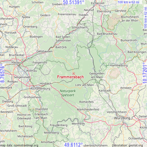
Frammersbach GPS coordinates[2]
50° 3' 52.848" North, 9° 28' 7.968" East
| Map corner | latitude | longitude |
|---|---|---|
| Upper-left | 50.51391°, | 8.76576° |
| Center: | 50.06468°, | 9.46888° |
| Lower-right: | 49.6112°, | 10.17201° |
| Map W x H: | 100.4×100.4 km | = 62.4×62.4mi |
| max Lat: | 55.01917° ⇑62.2% North |
| Frammersbach: | 50.06468° |
| min Lat: | ⇓37.8% South 47.40724° |
| min Long | Frammersbach | max Long |
| 5.92978° | 9.46888° | 14.98853° |
| W 41.7%⇐ | ⇒58.3% E |
Elevation
Elevation of Frammersbach is 228 m = 748 ft, and this is 21.1 m = 69 ft below average elevation for this country.
| Max E: |
1256 m = 4121 ft | 49.7% |
| Avg. | 249.1 m = 817 ft | |
| Frammersbach | 228 m = 748 ft | |
Min E: |
-5 m = -16 ft | 50.3% |
See also: Germany elevation on elevation.city.
Geographical zone
Frammersbach is located in North temperate zone (between Tropic of Cancer and the Arctic Circle). Distance of this North polar circle is 1834.5 km =1139.9 mi to North.| Distance of | km | miles | from Frammersbach |
|---|---|---|---|
| North Pole | 4440.4 | 2759.1 | to North |
| Arctic Circle | 1834.5 | 1139.9 | to North |
| Tropic Cancer | 2960.8 | 1839.8 | to South |
| Equator | 5566.7 | 3459 | to South |


Nearby cities:
15 places around Frammersbach: (largest is in red/bold)
• Aura im Sinngrund
14.7 km =9.1 mi,  31°
31°
• Fellen
12.5 km =7.8 mi,  40°
40°
• Heigenbrücken
8.1 km =5 mi,  239°
239°
• Heinrichsthal
9 km =5.6 mi,  274°
274°
• Laufach
13.2 km =8.2 mi,  246°
246°
• Lohr am Main
11.2 km =7 mi,  138°
138°
• Neuendorf
13.4 km =8.3 mi,  105°
105°
• Neuhütten
8.1 km =5 mi,  207°
207°
• Partenstein
4.4 km =2.7 mi,  124°
124°
• Rechtenbach
9.5 km =5.9 mi,  162°
162°
• Rieneck
13.2 km =8.2 mi,  75°
75°
• Rothenbuch
12.3 km =7.6 mi, 205°
• Sommerkahl
15.1 km =9.4 mi, 272°
• Wiesen
9.3 km =5.8 mi,  308°
308°
• Wiesthal
4.3 km =2.7 mi,  216°
216°
Sources, notices
• [Note1] Compared only with cities in Germany existing in our database
• [Src1] Map data: © OpenStreetMap contributors (CC-BY-SA)
• [Src2] Other city data from geonames.org with taken over terms of usage.
• [Src3] Geographical zone / Annual Mean Temperature by Robert A. Rohde @ Wikipedia
