Lohr am Main geodata
Lohr am Main (Bavaria) is a populated place; located in Germany in Europe/Berlin (GMT+2) time zone. With population of 16,127 people, there are 990 cities with bigger population in this country. Compared to other cities in Germany, 63.9% of cities are located further ↑North; 56.6% of cities are located further →East and 58.1% of cities have higher elevation than Lohr am Main. Note1
Administrative division(s):
- Level 1: Bavaria
- Level 2: Regierungsbezirk Unterfranken
- Level 3: Landkreis Main-Spessart
- Level 4: Lohr a.Main


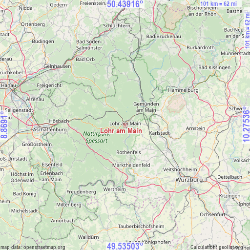
Lohr am Main GPS coordinates[2]
49° 59' 21.192" North, 9° 34' 20.028" East
| Map corner | latitude | longitude |
|---|---|---|
| Upper-left | 50.43916°, | 8.8691° |
| Center: | 49.98922°, | 9.57223° |
| Lower-right: | 49.53503°, | 10.27536° |
| Map W x H: | 100.5×100.5 km | = 62.4×62.4mi |
| max Lat: | 55.01917° ⇑63.9% North |
| Lohr am Main: | 49.98922° |
| min Lat: | ⇓36.1% South 47.40724° |
| min Long | Lohr am Main | max Long |
| 5.92978° | 9.57223° | 14.98853° |
| W 43.4%⇐ | ⇒56.6% E |
Elevation
Elevation of Lohr am Main is 167 m = 548 ft, and this is 82.1 m = 269 ft below average elevation for this country.
| Max E: |
1256 m = 4121 ft | 58.1% |
| Avg. | 249.1 m = 817 ft | |
| Lohr am Main | 167 m = 548 ft | |
Min E: |
-5 m = -16 ft | 41.9% |
See also: Germany elevation on elevation.city.
Geographical zone
Lohr am Main is located in North temperate zone (between Tropic of Cancer and the Arctic Circle). Distance of this North polar circle is 1842.9 km =1145.1 mi to North.| Distance of | km | miles | from Lohr am Main |
|---|---|---|---|
| North Pole | 4448.8 | 2764.4 | to North |
| Arctic Circle | 1842.9 | 1145.1 | to North |
| Tropic Cancer | 2952.4 | 1834.5 | to South |
| Equator | 5558.3 | 3453.8 | to South |


Nearby cities:
15 places around Lohr am Main: (largest is in red/bold)
• Erlenbach
5.3 km =3.3 mi,  102°
102°
• Frammersbach
11.2 km =7 mi,  318°
318°
• Gemünden am Main
11.7 km =7.3 mi,  54°
54°
• Neuendorf
7.4 km =4.6 mi, 48°
• Neuhütten
11.2 km =7 mi,  276°
276°
• Neustadt am Main
6.6 km =4.1 mi,  182°
182°
• Partenstein
6.9 km =4.3 mi,  327°
327°
• Rechtenbach
4.6 km =2.9 mi,  261°
261°
• Rieneck
12.8 km =8 mi,  25°
25°
• Roden
11.1 km =6.9 mi,  159°
159°
• Rothenbuch
13 km =8.1 mi, 258°
• Rothenfels
11 km =6.8 mi,  172°
172°
• Steinfeld
8 km =5 mi,  120°
120°
• Urspringen
12 km =7.5 mi,  143°
143°
• Wiesthal
11.1 km =6.9 mi,  296°
296°
Sources, notices
• [Note1] Compared only with cities in Germany existing in our database
• [Src1] Map data: © OpenStreetMap contributors (CC-BY-SA)
• [Src2] Other city data from geonames.org with taken over terms of usage.
• [Src3] Geographical zone / Annual Mean Temperature by Robert A. Rohde @ Wikipedia
