Rechtenbach geodata
Rechtenbach (Bavaria) is a seat of a fourth-order administrative division; located in Germany in Europe/Berlin (GMT+2) time zone. With population of 1,046 people, there are 7020 cities with bigger population in this country. Compared to other cities in Germany, 64.3% of cities are located further ↑North; 57.7% of cities are located further →East and 68.3% of cities have lower elevation than Rechtenbach. Note1
Administrative division(s):
- Level 1: Bavaria
- Level 2: Regierungsbezirk Unterfranken
- Level 3: Landkreis Main-Spessart
- Level 4: Rechtenbach


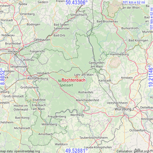
Rechtenbach GPS coordinates[2]
49° 58' 59.016" North, 9° 30' 29.988" East
| Map corner | latitude | longitude |
|---|---|---|
| Upper-left | 50.43306°, | 8.8052° |
| Center: | 49.98306°, | 9.50833° |
| Lower-right: | 49.52881°, | 10.21146° |
| Map W x H: | 100.5×100.5 km | = 62.4×62.4mi |
| max Lat: | 55.01917° ⇑64.3% North |
| Rechtenbach: | 49.98306° |
| min Lat: | ⇓35.7% South 47.40724° |
| min Long | Rechtenbach | max Long |
| 5.92978° | 9.50833° | 14.98853° |
| W 42.3%⇐ | ⇒57.7% E |
Elevation
Elevation of Rechtenbach is 345 m = 1132 ft, and this is 95.9 m = 315 ft above average elevation for this country.
| Max E: |
1256 m = 4121 ft | 31.7% |
| Rechtenbach | 345 m 1132 ft | |
| Avg. | 249.1 m = 817 ft | |
Min E: |
-5 m = -16 ft | 68.3% |
See also: Germany elevation on elevation.city.
Geographical zone
Rechtenbach is located in North temperate zone (between Tropic of Cancer and the Arctic Circle). Distance of this North polar circle is 1843.6 km =1145.6 mi to North.| Distance of | km | miles | from Rechtenbach |
|---|---|---|---|
| North Pole | 4449.5 | 2764.8 | to North |
| Arctic Circle | 1843.6 | 1145.6 | to North |
| Tropic Cancer | 2951.7 | 1834.1 | to South |
| Equator | 5557.6 | 3453.3 | to South |


Nearby cities:
15 places around Rechtenbach: (largest is in red/bold)
• Bischbrunn
12.6 km =7.8 mi,  186°
186°
• Erlenbach
9.8 km =6.1 mi,  92°
92°
• Frammersbach
9.5 km =5.9 mi,  342°
342°
• Heigenbrücken
11 km =6.8 mi,  297°
297°
• Lohr am Main
4.6 km =2.9 mi,  81°
81°
• Neuendorf
11.6 km =7.2 mi,  61°
61°
• Neuhütten
6.8 km =4.2 mi,  286°
286°
• Neustadt am Main
7.3 km =4.5 mi,  143°
143°
• Partenstein
6.6 km =4.1 mi,  7°
7°
• Roden
12.9 km =8 mi, 139°
• Rothenbuch
8.4 km =5.2 mi,  256°
256°
• Rothenfels
11.8 km =7.3 mi,  149°
149°
• Steinfeld
12 km =7.5 mi,  106°
106°
• Weibersbrunn
11.7 km =7.3 mi,  240°
240°
• Wiesthal
7.7 km =4.8 mi,  316°
316°
Sources, notices
• [Note1] Compared only with cities in Germany existing in our database
• [Src1] Map data: © OpenStreetMap contributors (CC-BY-SA)
• [Src2] Other city data from geonames.org with taken over terms of usage.
• [Src3] Geographical zone / Annual Mean Temperature by Robert A. Rohde @ Wikipedia
