Weyarn geodata
Weyarn (Bavaria) is a seat of a fourth-order administrative division; located in Germany in Europe/Berlin (GMT+2) time zone. With population of 3,217 people, there are 3815 cities with bigger population in this country. Compared to other cities in Germany, 97% of cities are located further ↑North; 78.8% of cities are located further ←West and 97.3% of cities have lower elevation than Weyarn. Note1
Administrative division(s):
- Level 1: Bavaria
- Level 2: Upper Bavaria
- Level 3: Landkreis Miesbach
- Level 4: Weyarn


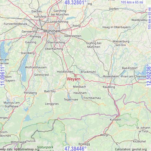
Weyarn GPS coordinates[2]
47° 51' 30.168" North, 11° 47' 57.228" East
| Map corner | latitude | longitude |
|---|---|---|
| Upper-left | 48.32801°, | 11.09611° |
| Center: | 47.85838°, | 11.79923° |
| Lower-right: | 47.38446°, | 12.50236° |
| Map W x H: | 104.9×104.9 km | = 65.2×65.2mi |
| max Lat: | 55.01917° ⇑97% North |
| Weyarn: | 47.85838° |
| min Lat: | ⇓3% South 47.40724° |
| min Long | Weyarn | max Long |
| 5.92978° | 11.79923° | 14.98853° |
| W 78.8%⇐ | ⇒21.2% E |
Elevation
Elevation of Weyarn is 673 m = 2208 ft, and this is 423.9 m = 1391 ft above average elevation for this country.
| Max E: |
1256 m = 4121 ft | 2.7% |
| Weyarn | 673 m 2208 ft | |
| Avg. | 249.1 m = 817 ft | |
Min E: |
-5 m = -16 ft | 97.3% |
See also: Germany elevation on elevation.city.
Geographical zone
Weyarn is located in North temperate zone (between Tropic of Cancer and the Arctic Circle). Distance of this North polar circle is 2079.8 km =1292.3 mi to North.| Distance of | km | miles | from Weyarn |
|---|---|---|---|
| North Pole | 4685.7 | 2911.6 | to North |
| Arctic Circle | 2079.8 | 1292.3 | to North |
| Tropic Cancer | 2715.4 | 1687.3 | to South |
| Equator | 5321.4 | 3306.6 | to South |


Nearby cities:
15 places around Weyarn: (largest is in red/bold)
• Aying
12.5 km =7.8 mi,  352°
352°
• Bruckmühl
8.6 km =5.3 mi,  74°
74°
• Feldkirchen-Westerham
6.3 km =3.9 mi,  30°
30°
• Gmund am Tegernsee
12.8 km =8 mi,  200°
200°
• Hausham
12.8 km =8 mi,  166°
166°
• Holzkirchen
7.5 km =4.7 mi,  285°
285°
• Irschenberg
9.2 km =5.7 mi,  107°
107°
• Miesbach
8.1 km =5 mi,  161°
161°
• Otterfing
10.8 km =6.7 mi,  301°
301°
• Sachsenkam
13 km =8.1 mi,  243°
243°
• Schliersee
14.3 km =8.9 mi, 161°
• Vagen
6.6 km =4.1 mi, 74°
• Valley
4.1 km =2.5 mi,  338°
338°
• Waakirchen
13.4 km =8.3 mi,  224°
224°
• Warngau
6.5 km =4 mi, 243°
Sources, notices
• [Note1] Compared only with cities in Germany existing in our database
• [Src1] Map data: © OpenStreetMap contributors (CC-BY-SA)
• [Src2] Other city data from geonames.org with taken over terms of usage.
• [Src3] Geographical zone / Annual Mean Temperature by Robert A. Rohde @ Wikipedia
