Bruckmühl geodata
Bruckmühl (Bavaria) is a populated place; located in Germany in Europe/Berlin (GMT+2) time zone. With population of 15,851 people, there are 1013 cities with bigger population in this country. Compared to other cities in Germany, 96.9% of cities are located further ↑North; 80.5% of cities are located further ←West and 90% of cities have lower elevation than Bruckmühl. Note1
Administrative division(s):
- Level 1: Bavaria
- Level 2: Upper Bavaria
- Level 3: Landkreis Rosenheim
- Level 4: Bruckmühl, Markt


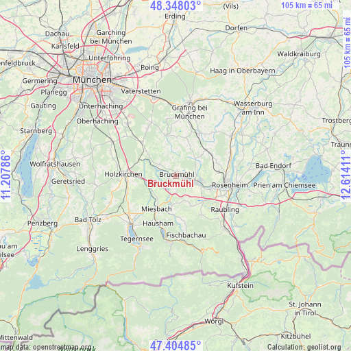
Bruckmühl GPS coordinates[2]
47° 52' 42.924" North, 11° 54' 39.528" East
| Map corner | latitude | longitude |
|---|---|---|
| Upper-left | 48.34803°, | 11.20786° |
| Center: | 47.87859°, | 11.91098° |
| Lower-right: | 47.40485°, | 12.61411° |
| Map W x H: | 104.9×104.9 km | = 65.2×65.2mi |
| max Lat: | 55.01917° ⇑96.9% North |
| Bruckmühl: | 47.87859° |
| min Lat: | ⇓3.1% South 47.40724° |
| min Long | Bruckmühl | max Long |
| 5.92978° | 11.91098° | 14.98853° |
| W 80.5%⇐ | ⇒19.5% E |
Elevation
Elevation of Bruckmühl is 514 m = 1686 ft, and this is 264.9 m = 869 ft above average elevation for this country.
| Max E: |
1256 m = 4121 ft | 10% |
| Bruckmühl | 514 m 1686 ft | |
| Avg. | 249.1 m = 817 ft | |
Min E: |
-5 m = -16 ft | 90% |
See also: Germany elevation on elevation.city.
Geographical zone
Bruckmühl is located in North temperate zone (between Tropic of Cancer and the Arctic Circle). Distance of this North polar circle is 2077.6 km =1291 mi to North.| Distance of | km | miles | from Bruckmühl |
|---|---|---|---|
| North Pole | 4683.5 | 2910.2 | to North |
| Arctic Circle | 2077.6 | 1291 | to North |
| Tropic Cancer | 2717.7 | 1688.7 | to South |
| Equator | 5323.6 | 3307.9 | to South |


Nearby cities:
15 places around Bruckmühl: (largest is in red/bold)
• Aying
14.2 km =8.8 mi,  315°
315°
• Bad Aibling
7.6 km =4.7 mi,  102°
102°
• Bad Feilnbach
13.8 km =8.6 mi,  147°
147°
• Feldkirchen-Westerham
6 km =3.7 mi,  302°
302°
• Glonn
12.5 km =7.8 mi,  344°
344°
• Großkarolinenfeld
12.8 km =8 mi,  83°
83°
• Hohenthann
11.5 km =7.1 mi,  17°
17°
• Irschenberg
5.1 km =3.2 mi,  175°
175°
• Kolbermoor
12.1 km =7.5 mi,  105°
105°
• Miesbach
11.5 km =7.1 mi,  210°
210°
• Rott
14 km =8.7 mi,  70°
70°
• Tuntenhausen
10 km =6.2 mi,  51°
51°
• Vagen
2 km =1.2 mi,  255°
255°
• Valley
10 km =6.2 mi,  279°
279°
• Weyarn
8.6 km =5.3 mi,  254°
254°
Sources, notices
• [Note1] Compared only with cities in Germany existing in our database
• [Src1] Map data: © OpenStreetMap contributors (CC-BY-SA)
• [Src2] Other city data from geonames.org with taken over terms of usage.
• [Src3] Geographical zone / Annual Mean Temperature by Robert A. Rohde @ Wikipedia
