Valley geodata
Valley (Bavaria) is a seat of a fourth-order administrative division; located in Germany in Europe/Berlin (GMT+2) time zone. With population of 2,968 people, there are 4031 cities with bigger population in this country. Compared to other cities in Germany, 96.8% of cities are located further ↑North; 78.5% of cities are located further ←West and 96.7% of cities have lower elevation than Valley. Note1
Administrative division(s):
- Level 1: Bavaria
- Level 2: Upper Bavaria
- Level 3: Landkreis Miesbach
- Level 4: Valley


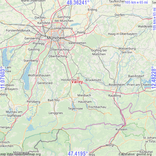
Valley GPS coordinates[2]
47° 53' 35.16" North, 11° 46' 44.94" East
| Map corner | latitude | longitude |
|---|---|---|
| Upper-left | 48.36241°, | 11.07603° |
| Center: | 47.8931°, | 11.77915° |
| Lower-right: | 47.4195°, | 12.48228° |
| Map W x H: | 104.8×104.8 km | = 65.1×65.1mi |
| max Lat: | 55.01917° ⇑96.8% North |
| Valley: | 47.8931° |
| min Lat: | ⇓3.2% South 47.40724° |
| min Long | Valley | max Long |
| 5.92978° | 11.77915° | 14.98853° |
| W 78.5%⇐ | ⇒21.5% E |
Elevation
Elevation of Valley is 650 m = 2133 ft, and this is 400.9 m = 1315 ft above average elevation for this country.
| Max E: |
1256 m = 4121 ft | 3.3% |
| Valley | 650 m 2133 ft | |
| Avg. | 249.1 m = 817 ft | |
Min E: |
-5 m = -16 ft | 96.7% |
See also: Germany elevation on elevation.city.
Geographical zone
Valley is located in North temperate zone (between Tropic of Cancer and the Arctic Circle). Distance of this North polar circle is 2076 km =1290 mi to North.| Distance of | km | miles | from Valley |
|---|---|---|---|
| North Pole | 4681.8 | 2909.1 | to North |
| Arctic Circle | 2076 | 1290 | to North |
| Tropic Cancer | 2719.3 | 1689.7 | to South |
| Equator | 5325.2 | 3308.9 | to South |


Nearby cities:
15 places around Valley: (largest is in red/bold)
• Aying
8.6 km =5.3 mi,  359°
359°
• Bruckmühl
10 km =6.2 mi,  99°
99°
• Brunnthal
14.5 km =9 mi,  330°
330°
• Egmating
12.4 km =7.7 mi,  5°
5°
• Feldkirchen-Westerham
5 km =3.1 mi,  71°
71°
• Glonn
12.4 km =7.7 mi,  31°
31°
• Holzkirchen
6.1 km =3.8 mi,  252°
252°
• Irschenberg
12.2 km =7.6 mi,  122°
122°
• Miesbach
12.3 km =7.6 mi,  160°
160°
• Otterfing
7.9 km =4.9 mi,  282°
282°
• Sachsenkam
14 km =8.7 mi,  225°
225°
• Sauerlach
12.8 km =8 mi,  313°
313°
• Vagen
8.1 km =5 mi,  105°
105°
• Warngau
8 km =5 mi,  212°
212°
• Weyarn
4.1 km =2.5 mi, 158°
Sources, notices
• [Note1] Compared only with cities in Germany existing in our database
• [Src1] Map data: © OpenStreetMap contributors (CC-BY-SA)
• [Src2] Other city data from geonames.org with taken over terms of usage.
• [Src3] Geographical zone / Annual Mean Temperature by Robert A. Rohde @ Wikipedia
