Westerland geodata
Westerland (Schleswig-Holstein) is a populated place; located in Germany in Europe/Berlin (GMT+2) time zone. With population of 8,967 people, there are 1796 cities with bigger population in this country. Compared to other cities in Germany, 100% of cities are located further ↓South; 72.9% of cities are located further →East and 95.2% of cities have higher elevation than Westerland. Note1


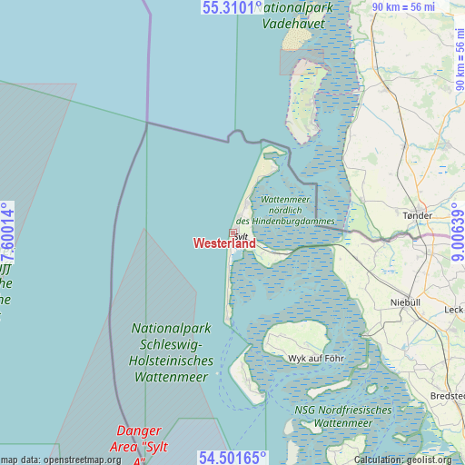
Westerland GPS coordinates[2]
54° 54' 28.44" North, 8° 18' 11.736" East
| Map corner | latitude | longitude |
|---|---|---|
| Upper-left | 55.3101°, | 7.60014° |
| Center: | 54.9079°, | 8.30326° |
| Lower-right: | 54.50165°, | 9.00639° |
| Map W x H: | 89.9×89.9 km | = 55.9×55.9mi |
| max Lat: | 55.01917° ⇑0% North |
| Westerland: | 54.9079° |
| min Lat: | ⇓100% South 47.40724° |
| min Long | Westerland | max Long |
| 5.92978° | 8.30326° | 14.98853° |
| W 27.1%⇐ | ⇒72.9% E |
Elevation
Elevation of Westerland is 8 m = 26 ft, and this is 241.1 m = 791 ft below average elevation for this country.
| Max E: |
1256 m = 4121 ft | 95.2% |
| Avg. | 249.1 m = 817 ft | |
| Westerland | 8 m = 26 ft | |
Min E: |
-5 m = -16 ft | 4.8% |
See also: Germany elevation on elevation.city.
Geographical zone
Westerland is located in North temperate zone (between Tropic of Cancer and the Arctic Circle). Distance of this North polar circle is 1296 km =805.3 mi to North.| Distance of | km | miles | from Westerland |
|---|---|---|---|
| North Pole | 3901.9 | 2424.5 | to North |
| Arctic Circle | 1296 | 805.3 | to North |
| Tropic Cancer | 3499.3 | 2174.4 | to South |
| Equator | 6105.2 | 3793.6 | to South |


Nearby cities:
15 places around Westerland: (largest is in red/bold)
• Borgsum
25.1 km =15.6 mi,  156°
156°
• Dunsum
21.1 km =13.1 mi, 158°
• Friedrich-Wilhelm-Lübke-Koog
21.6 km =13.4 mi,  102°
102°
• Hörnum
16.8 km =10.4 mi,  183°
183°
• Kampen
5.7 km =3.5 mi,  25°
25°
• Keitum
4.6 km =2.9 mi,  110°
110°
• Klanxbüll
24.4 km =15.2 mi, 101°
• List
14.8 km =9.2 mi, 33°
• Oldsum
21.7 km =13.5 mi, 155°
• Rantum
6.9 km =4.3 mi,  185°
185°
• Sylt-Ost
8.7 km =5.4 mi,  126°
126°
• Süderende
22 km =13.7 mi, 156°
• Tinnum
2.2 km =1.4 mi,  115°
115°
• Utersum
22.5 km =14 mi, 162°
• Witsum
24.8 km =15.4 mi, 159°
Sources, notices
• [Note1] Compared only with cities in Germany existing in our database
• [Src1] Map data: © OpenStreetMap contributors (CC-BY-SA)
• [Src2] Other city data from geonames.org with taken over terms of usage.
• [Src3] Geographical zone / Annual Mean Temperature by Robert A. Rohde @ Wikipedia
