Kampen geodata
Kampen (Schleswig-Holstein) is a populated place; located in Germany in Europe/Berlin (GMT+2) time zone. With population of 516 people, there are 9283 cities with bigger population in this country. Compared to other cities in Germany, 100% of cities are located further ↓South; 72.5% of cities are located further →East and 88% of cities have higher elevation than Kampen. Note1
Administrative division(s):
- Level 1: Schleswig-Holstein
- Level 3: Kreis Nordfriesland
- Level 4: Kampen (Sylt)


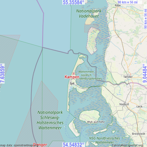
Kampen GPS coordinates[2]
54° 57' 14.796" North, 8° 20' 30.156" East
| Map corner | latitude | longitude |
|---|---|---|
| Upper-left | 55.35584°, | 7.63859° |
| Center: | 54.95411°, | 8.34171° |
| Lower-right: | 54.54832°, | 9.04484° |
| Map W x H: | 89.8×89.8 km | = 55.8×55.8mi |
| max Lat: | 55.01917° ⇑0% North |
| Kampen: | 54.95411° |
| min Lat: | ⇓100% South 47.40724° |
| min Long | Kampen | max Long |
| 5.92978° | 8.34171° | 14.98853° |
| W 27.5%⇐ | ⇒72.5% E |
Elevation
Elevation of Kampen is 27 m = 89 ft, and this is 222.1 m = 729 ft below average elevation for this country.
| Max E: |
1256 m = 4121 ft | 88% |
| Avg. | 249.1 m = 817 ft | |
| Kampen | 27 m = 89 ft | |
Min E: |
-5 m = -16 ft | 12% |
See also: Germany elevation on elevation.city.
Geographical zone
Kampen is located in North temperate zone (between Tropic of Cancer and the Arctic Circle). Distance of this North polar circle is 1290.8 km =802.1 mi to North.| Distance of | km | miles | from Kampen |
|---|---|---|---|
| North Pole | 3896.7 | 2421.3 | to North |
| Arctic Circle | 1290.8 | 802.1 | to North |
| Tropic Cancer | 3504.4 | 2177.5 | to South |
| Equator | 6110.3 | 3796.8 | to South |


Nearby cities:
15 places around Kampen: (largest is in red/bold)
• Dunsum
25.3 km =15.7 mi,  167°
167°
• Friedrich-Wilhelm-Lübke-Koog
21 km =13 mi,  117°
117°
• Hörnum
22.1 km =13.7 mi,  188°
188°
• Keitum
7 km =4.3 mi,  164°
164°
• Klanxbüll
23.7 km =14.7 mi, 115°
• List
9.2 km =5.7 mi,  38°
38°
• Neukirchen
26.9 km =16.7 mi,  111°
111°
• Oldsum
25.7 km =16 mi, 165°
• Rantum
12.4 km =7.7 mi, 194°
• Rodenäs
24.2 km =15 mi, 108°
• Sylt-Ost
11.3 km =7 mi, 156°
• Süderende
26.1 km =16.2 mi, 166°
• Tinnum
6.1 km =3.8 mi,  184°
184°
• Utersum
27 km =16.8 mi, 171°
• Westerland
5.7 km =3.5 mi,  205°
205°
Sources, notices
• [Note1] Compared only with cities in Germany existing in our database
• [Src1] Map data: © OpenStreetMap contributors (CC-BY-SA)
• [Src2] Other city data from geonames.org with taken over terms of usage.
• [Src3] Geographical zone / Annual Mean Temperature by Robert A. Rohde @ Wikipedia
