Derenburg geodata
Derenburg (Saxony-Anhalt) is a populated place; located in Germany in Europe/Berlin (GMT+2) time zone. With population of 2,716 people, there are 4219 cities with bigger population in this country. Compared to other cities in Germany, 70.8% of cities are located further ↓South; 65.6% of cities are located further ←West and 59.4% of cities have higher elevation than Derenburg. Note1
Administrative division(s):
- Level 1: Saxony-Anhalt
- Level 3: Landkreis Harz
- Level 4: Blankenburg (Harz)


Derenburg GPS coordinates[2]
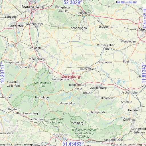
51° 52' 15.096" North, 10° 54' 37.044" East
| Map corner | latitude | longitude |
|---|---|---|
| Upper-left | 52.3029°, | 10.20717° |
| Center: | 51.87086°, | 10.91029° |
| Lower-right: | 51.43463°, | 11.61342° |
| Map W x H: | 96.5×96.5 km | = 60×60mi |
| max Lat: | 55.01917° ⇑29.2% North |
| Derenburg: | 51.87086° |
| min Lat: | ⇓70.8% South 47.40724° |
| min Long | Derenburg | max Long |
| 5.92978° | 10.91029° | 14.98853° |
| W 65.6%⇐ | ⇒34.4% E |
Elevation
Elevation of Derenburg is 157 m = 515 ft, and this is 92.1 m = 302 ft below average elevation for this country.
| Max E: |
1256 m = 4121 ft | 59.4% |
| Avg. | 249.1 m = 817 ft | |
| Derenburg | 157 m = 515 ft | |
Min E: |
-5 m = -16 ft | 40.6% |
See also: Germany elevation on elevation.city.
Geographical zone
Derenburg is located in North temperate zone (between Tropic of Cancer and the Arctic Circle). Distance of this North polar circle is 1633.7 km =1015.1 mi to North.| Distance of | km | miles | from Derenburg |
|---|---|---|---|
| North Pole | 4239.6 | 2634.4 | to North |
| Arctic Circle | 1633.7 | 1015.1 | to North |
| Tropic Cancer | 3161.6 | 1964.5 | to South |
| Equator | 5767.5 | 3583.8 | to South |


Nearby cities:
15 places around Derenburg: (largest is in red/bold)
• Aspenstedt
7.7 km =4.8 mi,  20°
20°
• Blankenburg
9.5 km =5.9 mi,  161°
161°
• Cattenstedt
11.2 km =7 mi, 159°
• Danstedt
4.9 km =3 mi,  340°
340°
• Halberstadt
10.4 km =6.5 mi,  74°
74°
• Heimburg
5.3 km =3.3 mi,  179°
179°
• Heudeber
5.8 km =3.6 mi,  307°
307°
• Huy-Neinstedt
10.6 km =6.6 mi,  1°
1°
• Hüttenrode
11.4 km =7.1 mi, 182°
• Langeln
9.2 km =5.7 mi,  299°
299°
• Langenstein
5.6 km =3.5 mi,  107°
107°
• Reddeber
7.3 km =4.5 mi,  265°
265°
• Sargstedt
9.4 km =5.8 mi,  33°
33°
• Ströbeck
5.3 km =3.3 mi, 26°
• Wernigerode
9.6 km =6 mi,  246°
246°
Sources, notices
• [Note1] Compared only with cities in Germany existing in our database
• [Src1] Map data: © OpenStreetMap contributors (CC-BY-SA)
• [Src2] Other city data from geonames.org with taken over terms of usage.
• [Src3] Geographical zone / Annual Mean Temperature by Robert A. Rohde @ Wikipedia
