Auerbach geodata
Auerbach (Saxony) is a populated place; located in Germany in Europe/Berlin (GMT+2) time zone. With population of 21,358 people, there are 711 cities with bigger population in this country. Compared to other cities in Germany, 52.6% of cities are located further ↑North; 87% of cities are located further ←West and 83.6% of cities have lower elevation than Auerbach. Note1


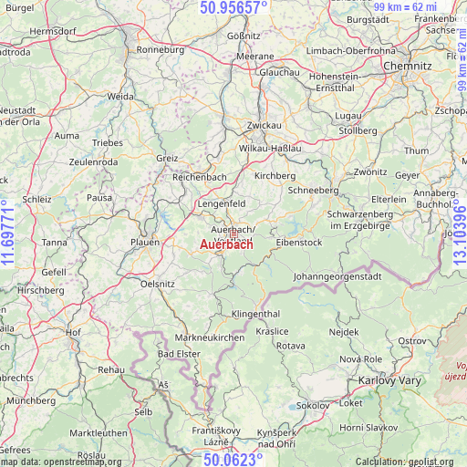
Auerbach GPS coordinates[2]
50° 30' 41.58" North, 12° 24' 2.988" East
| Map corner | latitude | longitude |
|---|---|---|
| Upper-left | 50.95657°, | 11.69771° |
| Center: | 50.51155°, | 12.40083° |
| Lower-right: | 50.0623°, | 13.10396° |
| Map W x H: | 99.4×99.4 km | = 61.8×61.8mi |
| max Lat: | 55.01917° ⇑52.6% North |
| Auerbach: | 50.51155° |
| min Lat: | ⇓47.4% South 47.40724° |
| min Long | Auerbach | max Long |
| 5.92978° | 12.40083° | 14.98853° |
| W 87%⇐ | ⇒13% E |
Elevation
Elevation of Auerbach is 458 m = 1503 ft, and this is 208.9 m = 685 ft above average elevation for this country.
| Max E: |
1256 m = 4121 ft | 16.4% |
| Auerbach | 458 m 1503 ft | |
| Avg. | 249.1 m = 817 ft | |
Min E: |
-5 m = -16 ft | 83.6% |
See also: Germany elevation on elevation.city.
Geographical zone
Auerbach is located in North temperate zone (between Tropic of Cancer and the Arctic Circle). Distance of this North polar circle is 1784.8 km =1109 mi to North.| Distance of | km | miles | from Auerbach |
|---|---|---|---|
| North Pole | 4390.7 | 2728.3 | to North |
| Arctic Circle | 1784.8 | 1109 | to North |
| Tropic Cancer | 3010.4 | 1870.6 | to South |
| Equator | 5616.4 | 3489.9 | to South |


Nearby cities:
15 places around Auerbach: (largest is in red/bold)
• Bergen
10 km =6.2 mi,  243°
243°
• Ellefeld
3.2 km =2 mi,  195°
195°
• Falkenstein
4.3 km =2.7 mi,  209°
209°
• Grünbach
7.4 km =4.6 mi, 201°
• Hammerbrücke
8.6 km =5.3 mi,  173°
173°
• Lengenfeld
6.9 km =4.3 mi,  338°
338°
• Muldenhammer
9 km =5.6 mi,  139°
139°
• Neustadt Vogtland
7.4 km =4.6 mi,  220°
220°
• Rodewisch
2.3 km =1.4 mi,  22°
22°
• Schönheide
8.6 km =5.3 mi,  95°
95°
• Stützengrün
9.7 km =6 mi,  75°
75°
• Tannenbergsthal
9.2 km =5.7 mi,  154°
154°
• Treuen
7.7 km =4.8 mi,  296°
296°
• Waldkirchen
9.6 km =6 mi,  351°
351°
• Werda
10.6 km =6.6 mi, 219°
Sources, notices
• [Note1] Compared only with cities in Germany existing in our database
• [Src1] Map data: © OpenStreetMap contributors (CC-BY-SA)
• [Src2] Other city data from geonames.org with taken over terms of usage.
• [Src3] Geographical zone / Annual Mean Temperature by Robert A. Rohde @ Wikipedia
