Sassen geodata
Sassen (Mecklenburg-Vorpommern) is a populated place; located in Germany in Europe/Berlin (GMT+2) time zone. With population of 543 people, there are 9125 cities with bigger population in this country. Compared to other cities in Germany, 93% of cities are located further ↓South; 93.6% of cities are located further ←West and 87.7% of cities have higher elevation than Sassen. Note1
Administrative division(s):
- Level 1: Mecklenburg-Vorpommern
- Level 3: Vorpommern-Greifswald
- Level 4: Sassen-Trantow


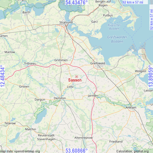
Sassen GPS coordinates[2]
54° 1' 25.536" North, 13° 11' 14.856" East
| Map corner | latitude | longitude |
|---|---|---|
| Upper-left | 54.43476°, | 12.48434° |
| Center: | 54.02376°, | 13.18746° |
| Lower-right: | 53.60866°, | 13.89059° |
| Map W x H: | 91.9×91.9 km | = 57.1×57.1mi |
| max Lat: | 55.01917° ⇑7% North |
| Sassen: | 54.02376° |
| min Lat: | ⇓93% South 47.40724° |
| min Long | Sassen | max Long |
| 5.92978° | 13.18746° | 14.98853° |
| W 93.6%⇐ | ⇒6.4% E |
Elevation
Elevation of Sassen is 28 m = 92 ft, and this is 221.1 m = 725 ft below average elevation for this country.
| Max E: |
1256 m = 4121 ft | 87.7% |
| Avg. | 249.1 m = 817 ft | |
| Sassen | 28 m = 92 ft | |
Min E: |
-5 m = -16 ft | 12.3% |
See also: Germany elevation on elevation.city.
Geographical zone
Sassen is located in North temperate zone (between Tropic of Cancer and the Arctic Circle). Distance of this North polar circle is 1394.3 km =866.4 mi to North.| Distance of | km | miles | from Sassen |
|---|---|---|---|
| North Pole | 4000.2 | 2485.6 | to North |
| Arctic Circle | 1394.3 | 866.4 | to North |
| Tropic Cancer | 3401 | 2113.3 | to South |
| Equator | 6006.9 | 3732.5 | to South |


Nearby cities:
15 places around Sassen: (largest is in red/bold)
• Bandelin
13.9 km =8.6 mi,  118°
118°
• Behrenhoff
13.4 km =8.3 mi,  98°
98°
• Bentzin
10.3 km =6.4 mi,  147°
147°
• Dersekow
7.3 km =4.5 mi,  70°
70°
• Düvier
7.8 km =4.8 mi,  263°
263°
• Greifswald
15.2 km =9.4 mi,  59°
59°
• Grimmen
13.7 km =8.5 mi,  315°
315°
• Görmin
6.5 km =4 mi, 123°
• Hinrichshagen Hof
12 km =7.5 mi, 62°
• Jarmen
14.9 km =9.3 mi,  138°
138°
• Kruckow
14 km =8.7 mi,  165°
165°
• Mesekenhagen
16.3 km =10.1 mi,  31°
31°
• Tutow
12.7 km =7.9 mi,  161°
161°
• Weitenhagen
14.9 km =9.3 mi,  77°
77°
• Ückeritz
11.3 km =7 mi,  180°
180°
Sources, notices
• [Note1] Compared only with cities in Germany existing in our database
• [Src1] Map data: © OpenStreetMap contributors (CC-BY-SA)
• [Src2] Other city data from geonames.org with taken over terms of usage.
• [Src3] Geographical zone / Annual Mean Temperature by Robert A. Rohde @ Wikipedia
