Weitenhagen geodata
Weitenhagen (Mecklenburg-Vorpommern) is a populated place; located in Germany in Europe/Berlin (GMT+2) time zone. With population of 1,604 people, there are 5677 cities with bigger population in this country. Compared to other cities in Germany, 93.4% of cities are located further ↓South; 95.2% of cities are located further ←West and 86.3% of cities have higher elevation than Weitenhagen. Note1
Administrative division(s):
- Level 1: Mecklenburg-Vorpommern
- Level 3: Vorpommern-Greifswald
- Level 4: Weitenhagen


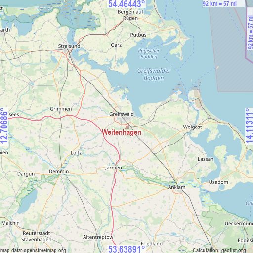
Weitenhagen GPS coordinates[2]
54° 3' 13.392" North, 13° 24' 35.928" East
| Map corner | latitude | longitude |
|---|---|---|
| Upper-left | 54.46443°, | 12.70686° |
| Center: | 54.05372°, | 13.40998° |
| Lower-right: | 53.63891°, | 14.11311° |
| Map W x H: | 91.8×91.8 km | = 57×57mi |
| max Lat: | 55.01917° ⇑6.6% North |
| Weitenhagen: | 54.05372° |
| min Lat: | ⇓93.4% South 47.40724° |
| min Long | Weitenhagen | max Long |
| 5.92978° | 13.40998° | 14.98853° |
| W 95.2%⇐ | ⇒4.8% E |
Elevation
Elevation of Weitenhagen is 32 m = 105 ft, and this is 217.1 m = 712 ft below average elevation for this country.
| Max E: |
1256 m = 4121 ft | 86.3% |
| Avg. | 249.1 m = 817 ft | |
| Weitenhagen | 32 m = 105 ft | |
Min E: |
-5 m = -16 ft | 13.7% |
See also: Germany elevation on elevation.city.
Geographical zone
Weitenhagen is located in North temperate zone (between Tropic of Cancer and the Arctic Circle). Distance of this North polar circle is 1391 km =864.3 mi to North.| Distance of | km | miles | from Weitenhagen |
|---|---|---|---|
| North Pole | 3996.9 | 2483.6 | to North |
| Arctic Circle | 1391 | 864.3 | to North |
| Tropic Cancer | 3404.3 | 2115.3 | to South |
| Equator | 6010.2 | 3734.6 | to South |


Nearby cities:
15 places around Weitenhagen: (largest is in red/bold)
• Bandelin
10.3 km =6.4 mi,  193°
193°
• Behrenhoff
5.5 km =3.4 mi, 193°
• Bentzin
14.9 km =9.3 mi,  216°
216°
• Brünzow
11.6 km =7.2 mi,  60°
60°
• Dersekow
7.7 km =4.8 mi,  263°
263°
• Greifswald
4.6 km =2.9 mi,  341°
341°
• Groß Kiesow
6.4 km =4 mi,  135°
135°
• Görmin
11.5 km =7.1 mi,  232°
232°
• Hanshagen
8.7 km =5.4 mi,  96°
96°
• Hinrichshagen Hof
4.5 km =2.8 mi,  300°
300°
• Kemnitz
8.6 km =5.3 mi,  72°
72°
• Loissin
10.1 km =6.3 mi,  49°
49°
• Mesekenhagen
12.1 km =7.5 mi,  330°
330°
• Neu Boltenhagen
13.1 km =8.1 mi,  83°
83°
• Züssow
12.4 km =7.7 mi,  133°
133°
Sources, notices
• [Note1] Compared only with cities in Germany existing in our database
• [Src1] Map data: © OpenStreetMap contributors (CC-BY-SA)
• [Src2] Other city data from geonames.org with taken over terms of usage.
• [Src3] Geographical zone / Annual Mean Temperature by Robert A. Rohde @ Wikipedia
