Greifswald geodata
Greifswald (Mecklenburg-Vorpommern) is a seat of a third-order administrative division; located in Germany in Europe/Berlin (GMT+2) time zone. With population of 52,731 people, there are 207 cities with bigger population in this country. Compared to other cities in Germany, 93.8% of cities are located further ↓South; 95% of cities are located further ←West and 97% of cities have higher elevation than Greifswald. Note1
Administrative division(s):
- Level 1: Mecklenburg-Vorpommern
- Level 3: Vorpommern-Greifswald
- Level 4: Greifswald, Hansestadt


Greifswald GPS coordinates[2]
54° 5' 35.196" North, 13° 23' 16.296" East
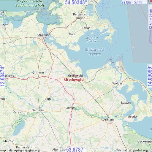
| Map corner | latitude | longitude |
|---|---|---|
| Upper-left | 54.50343°, | 12.68474° |
| Center: | 54.09311°, | 13.38786° |
| Lower-right: | 53.6787°, | 14.09099° |
| Map W x H: | 91.7×91.7 km | = 57×57mi |
| max Lat: | 55.01917° ⇑6.2% North |
| Greifswald: | 54.09311° |
| min Lat: | ⇓93.8% South 47.40724° |
| min Long | Greifswald | max Long |
| 5.92978° | 13.38786° | 14.98853° |
| W 95%⇐ | ⇒5% E |
Elevation
Elevation of Greifswald is 4 m = 13 ft, and this is 245.1 m = 804 ft below average elevation for this country.
| Max E: |
1256 m = 4121 ft | 97% |
| Avg. | 249.1 m = 817 ft | |
| Greifswald | 4 m = 13 ft | |
Min E: |
-5 m = -16 ft | 3% |
See also: Greifswald elevation on elevation.city.
Geographical zone
Greifswald is located in North temperate zone (between Tropic of Cancer and the Arctic Circle). Distance of this North polar circle is 1386.6 km =861.6 mi to North.| Distance of | km | miles | from Greifswald |
|---|---|---|---|
| North Pole | 3992.5 | 2480.8 | to North |
| Arctic Circle | 1386.6 | 861.6 | to North |
| Tropic Cancer | 3408.7 | 2118.1 | to South |
| Equator | 6014.6 | 3737.3 | to South |


Nearby cities:
15 places around Greifswald: (largest is in red/bold)
• Bandelin
14.4 km =8.9 mi,  183°
183°
• Behrenhoff
9.7 km =6 mi, 179°
• Brünzow
11.6 km =7.2 mi,  83°
83°
• Dersekow
8.1 km =5 mi,  229°
229°
• Groß Kiesow
10.7 km =6.6 mi,  146°
146°
• Görmin
13.7 km =8.5 mi,  213°
213°
• Hanshagen
11.4 km =7.1 mi,  117°
117°
• Hinrichshagen Hof
3.2 km =2 mi, 228°
• Kemnitz
9.8 km =6.1 mi,  100°
100°
• Kirchdorf
11.7 km =7.3 mi,  320°
320°
• Loissin
9.4 km =5.8 mi, 77°
• Mesekenhagen
7.6 km =4.7 mi, 323°
• Neu Boltenhagen
14.8 km =9.2 mi, 101°
• Weitenhagen
4.6 km =2.9 mi,  161°
161°
• Wusterhusen
15 km =9.3 mi, 81°
Sources, notices
• [Note1] Compared only with cities in Germany existing in our database
• [Src1] Map data: © OpenStreetMap contributors (CC-BY-SA)
• [Src2] Other city data from geonames.org with taken over terms of usage.
• [Src3] Geographical zone / Annual Mean Temperature by Robert A. Rohde @ Wikipedia
