Hanshagen geodata
Hanshagen (Mecklenburg-Vorpommern) is a populated place; located in Germany in Europe/Berlin (GMT+2) time zone. With population of 910 people, there are 7488 cities with bigger population in this country. Compared to other cities in Germany, 93.2% of cities are located further ↓South; 96% of cities are located further ←West and 86.3% of cities have higher elevation than Hanshagen. Note1
Administrative division(s):
- Level 1: Mecklenburg-Vorpommern
- Level 3: Vorpommern-Greifswald
- Level 4: Hanshagen


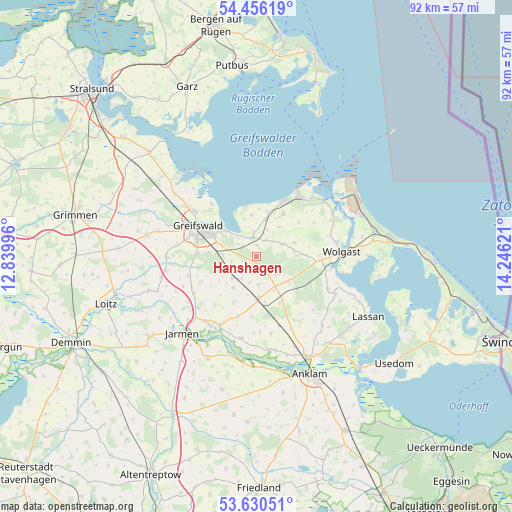
Hanshagen GPS coordinates[2]
54° 2' 43.44" North, 13° 32' 35.088" East
| Map corner | latitude | longitude |
|---|---|---|
| Upper-left | 54.45619°, | 12.83996° |
| Center: | 54.0454°, | 13.54308° |
| Lower-right: | 53.63051°, | 14.24621° |
| Map W x H: | 91.8×91.8 km | = 57×57mi |
| max Lat: | 55.01917° ⇑6.8% North |
| Hanshagen: | 54.0454° |
| min Lat: | ⇓93.2% South 47.40724° |
| min Long | Hanshagen | max Long |
| 5.92978° | 13.54308° | 14.98853° |
| W 96%⇐ | ⇒4% E |
Elevation
Elevation of Hanshagen is 32 m = 105 ft, and this is 217.1 m = 712 ft below average elevation for this country.
| Max E: |
1256 m = 4121 ft | 86.3% |
| Avg. | 249.1 m = 817 ft | |
| Hanshagen | 32 m = 105 ft | |
Min E: |
-5 m = -16 ft | 13.7% |
See also: Germany elevation on elevation.city.
Geographical zone
Hanshagen is located in North temperate zone (between Tropic of Cancer and the Arctic Circle). Distance of this North polar circle is 1391.9 km =864.9 mi to North.| Distance of | km | miles | from Hanshagen |
|---|---|---|---|
| North Pole | 3997.8 | 2484.1 | to North |
| Arctic Circle | 1391.9 | 864.9 | to North |
| Tropic Cancer | 3403.4 | 2114.8 | to South |
| Equator | 6009.3 | 3734 | to South |


Nearby cities:
15 places around Hanshagen: (largest is in red/bold)
• Behrenhoff
10.9 km =6.8 mi,  246°
246°
• Brünzow
6.7 km =4.2 mi,  12°
12°
• Greifswald
11.4 km =7.1 mi,  297°
297°
• Groß Kiesow
5.6 km =3.5 mi,  229°
229°
• Hinrichshagen Hof
12.9 km =8 mi,  284°
284°
• Hohendorf
12.4 km =7.7 mi,  98°
98°
• Katzow
8.8 km =5.5 mi,  88°
88°
• Kemnitz
3.6 km =2.2 mi,  351°
351°
• Loissin
7.5 km =4.7 mi, 352°
• Lubmin
11.1 km =6.9 mi,  25°
25°
• Lühmannsdorf
7.3 km =4.5 mi,  124°
124°
• Neu Boltenhagen
5 km =3.1 mi,  61°
61°
• Weitenhagen
8.7 km =5.4 mi, 276°
• Wusterhusen
8.9 km =5.5 mi, 32°
• Züssow
7.6 km =4.7 mi,  177°
177°
Sources, notices
• [Note1] Compared only with cities in Germany existing in our database
• [Src1] Map data: © OpenStreetMap contributors (CC-BY-SA)
• [Src2] Other city data from geonames.org with taken over terms of usage.
• [Src3] Geographical zone / Annual Mean Temperature by Robert A. Rohde @ Wikipedia
