Uichteritz geodata
Uichteritz (Saxony-Anhalt) is a populated place; located in Germany in Europe/Berlin (GMT+2) time zone. With population of 1,455 people, there are 5970 cities with bigger population in this country. Compared to other cities in Germany, 61.7% of cities are located further ↓South; 80.6% of cities are located further ←West and 68% of cities have higher elevation than Uichteritz. Note1


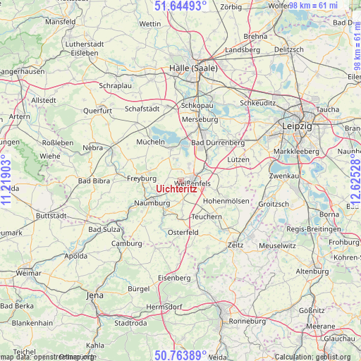
Uichteritz GPS coordinates[2]
51° 12' 23.472" North, 11° 55' 19.74" East
| Map corner | latitude | longitude |
|---|---|---|
| Upper-left | 51.64493°, | 11.21903° |
| Center: | 51.20652°, | 11.92215° |
| Lower-right: | 50.76389°, | 12.62528° |
| Map W x H: | 98×98 km | = 60.9×60.9mi |
| max Lat: | 55.01917° ⇑38.3% North |
| Uichteritz: | 51.20652° |
| min Lat: | ⇓61.7% South 47.40724° |
| min Long | Uichteritz | max Long |
| 5.92978° | 11.92215° | 14.98853° |
| W 80.6%⇐ | ⇒19.4% E |
Elevation
Elevation of Uichteritz is 102 m = 335 ft, and this is 147.1 m = 483 ft below average elevation for this country.
| Max E: |
1256 m = 4121 ft | 68% |
| Avg. | 249.1 m = 817 ft | |
| Uichteritz | 102 m = 335 ft | |
Min E: |
-5 m = -16 ft | 32% |
See also: Germany elevation on elevation.city.
Geographical zone
Uichteritz is located in North temperate zone (between Tropic of Cancer and the Arctic Circle). Distance of this North polar circle is 1707.5 km =1061 mi to North.| Distance of | km | miles | from Uichteritz |
|---|---|---|---|
| North Pole | 4313.4 | 2680.2 | to North |
| Arctic Circle | 1707.5 | 1061 | to North |
| Tropic Cancer | 3087.7 | 1918.6 | to South |
| Equator | 5693.6 | 3537.8 | to South |


Nearby cities:
15 places around Uichteritz: (largest is in red/bold)
• Burgwerben
4.7 km =2.9 mi,  67°
67°
• Dehlitz
7.5 km =4.7 mi, 68°
• Goseck
3.9 km =2.4 mi,  259°
259°
• Gröst
7.8 km =4.8 mi,  319°
319°
• Langendorf
4 km =2.5 mi,  137°
137°
• Leißling
2.8 km =1.7 mi,  198°
198°
• Markwerben
1.7 km =1.1 mi,  51°
51°
• Prittitz
6.3 km =3.9 mi,  174°
174°
• Reichardtswerben
5.2 km =3.2 mi,  25°
25°
• Schkortleben
7.8 km =4.8 mi,  58°
58°
• Schönburg
5.9 km =3.7 mi,  221°
221°
• Storkau
2.4 km =1.5 mi,  3°
3°
• Tagewerben
4 km =2.5 mi, 30°
• Weißenfels
3.3 km =2.1 mi,  99°
99°
• Zorbau
7.2 km =4.5 mi, 103°
Sources, notices
• [Note1] Compared only with cities in Germany existing in our database
• [Src1] Map data: © OpenStreetMap contributors (CC-BY-SA)
• [Src2] Other city data from geonames.org with taken over terms of usage.
• [Src3] Geographical zone / Annual Mean Temperature by Robert A. Rohde @ Wikipedia
