Tagewerben geodata
Tagewerben (Saxony-Anhalt) is a populated place; located in Germany in Europe/Berlin (GMT+2) time zone. With population of 829 people, there are 7777 cities with bigger population in this country. Compared to other cities in Germany, 62.1% of cities are located further ↓South; 81.2% of cities are located further ←West and 61.1% of cities have higher elevation than Tagewerben. Note1


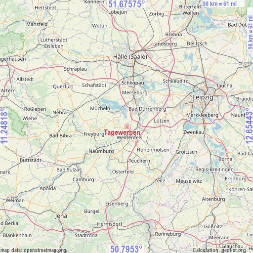
Tagewerben GPS coordinates[2]
51° 14' 15.468" North, 11° 57' 4.68" East
| Map corner | latitude | longitude |
|---|---|---|
| Upper-left | 51.67575°, | 11.24818° |
| Center: | 51.23763°, | 11.9513° |
| Lower-right: | 50.7953°, | 12.65443° |
| Map W x H: | 97.9×97.9 km | = 60.8×60.8mi |
| max Lat: | 55.01917° ⇑37.9% North |
| Tagewerben: | 51.23763° |
| min Lat: | ⇓62.1% South 47.40724° |
| min Long | Tagewerben | max Long |
| 5.92978° | 11.9513° | 14.98853° |
| W 81.2%⇐ | ⇒18.8% E |
Elevation
Elevation of Tagewerben is 145 m = 476 ft, and this is 104.1 m = 342 ft below average elevation for this country.
| Max E: |
1256 m = 4121 ft | 61.1% |
| Avg. | 249.1 m = 817 ft | |
| Tagewerben | 145 m = 476 ft | |
Min E: |
-5 m = -16 ft | 38.9% |
See also: Germany elevation on elevation.city.
Geographical zone
Tagewerben is located in North temperate zone (between Tropic of Cancer and the Arctic Circle). Distance of this North polar circle is 1704.1 km =1058.9 mi to North.| Distance of | km | miles | from Tagewerben |
|---|---|---|---|
| North Pole | 4310 | 2678.1 | to North |
| Arctic Circle | 1704.1 | 1058.9 | to North |
| Tropic Cancer | 3091.2 | 1920.8 | to South |
| Equator | 5697.1 | 3540 | to South |


Nearby cities:
15 places around Tagewerben: (largest is in red/bold)
• Braunsbedra
6.9 km =4.3 mi,  321°
321°
• Burgwerben
2.8 km =1.7 mi,  126°
126°
• Dehlitz
5 km =3.1 mi,  99°
99°
• Goseck
7.2 km =4.5 mi,  234°
234°
• Großkayna
6 km =3.7 mi,  347°
347°
• Großkorbetha
6 km =3.7 mi,  65°
65°
• Langendorf
6.5 km =4 mi,  173°
173°
• Leißling
6.8 km =4.2 mi,  205°
205°
• Markwerben
2.5 km =1.6 mi,  196°
196°
• Reichardtswerben
1.2 km =0.7 mi,  7°
7°
• Schkortleben
4.6 km =2.9 mi,  82°
82°
• Storkau
2.2 km =1.4 mi,  239°
239°
• Uichteritz
4 km =2.5 mi, 210°
• Weißenfels
4.2 km =2.6 mi,  163°
163°
• Zorbau
7.1 km =4.4 mi,  135°
135°
Sources, notices
• [Note1] Compared only with cities in Germany existing in our database
• [Src1] Map data: © OpenStreetMap contributors (CC-BY-SA)
• [Src2] Other city data from geonames.org with taken over terms of usage.
• [Src3] Geographical zone / Annual Mean Temperature by Robert A. Rohde @ Wikipedia
