Lindenberg geodata
Lindenberg (Rheinland-Pfalz) is a seat of a fourth-order administrative division; located in Germany in Europe/Berlin (GMT+2) time zone. With population of 1,178 people, there are 6627 cities with bigger population in this country. Compared to other cities in Germany, 77.5% of cities are located further ↑North; 75.5% of cities are located further →East and 51.6% of cities have higher elevation than Lindenberg. Note1
Administrative division(s):
- Level 1: Rheinland-Pfalz
- Level 3: Landkreis Bad Dürkheim
- Level 4: Lambrecht (Pfalz)


Lindenberg GPS coordinates[2]
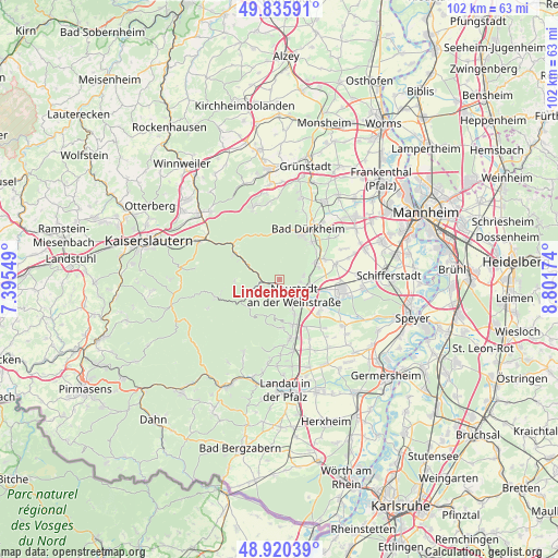
49° 22' 49.008" North, 8° 5' 54.996" East
| Map corner | latitude | longitude |
|---|---|---|
| Upper-left | 49.83591°, | 7.39549° |
| Center: | 49.38028°, | 8.09861° |
| Lower-right: | 48.92039°, | 8.80174° |
| Map W x H: | 101.8×101.8 km | = 63.3×63.3mi |
| max Lat: | 55.01917° ⇑77.5% North |
| Lindenberg: | 49.38028° |
| min Lat: | ⇓22.5% South 47.40724° |
| min Long | Lindenberg | max Long |
| 5.92978° | 8.09861° | 14.98853° |
| W 24.5%⇐ | ⇒75.5% E |
Elevation
Elevation of Lindenberg is 214 m = 702 ft, and this is 35.1 m = 115 ft below average elevation for this country.
| Max E: |
1256 m = 4121 ft | 51.6% |
| Avg. | 249.1 m = 817 ft | |
| Lindenberg | 214 m = 702 ft | |
Min E: |
-5 m = -16 ft | 48.4% |
See also: Germany elevation on elevation.city.
Geographical zone
Lindenberg is located in North temperate zone (between Tropic of Cancer and the Arctic Circle). Distance of this North polar circle is 1910.6 km =1187.2 mi to North.| Distance of | km | miles | from Lindenberg |
|---|---|---|---|
| North Pole | 4516.5 | 2806.4 | to North |
| Arctic Circle | 1910.6 | 1187.2 | to North |
| Tropic Cancer | 2884.7 | 1792.5 | to South |
| Equator | 5490.6 | 3411.7 | to South |


Nearby cities:
15 places around Lindenberg: (largest is in red/bold)
• Deidesheim
6.9 km =4.3 mi,  63°
63°
• Esthal
8.4 km =5.2 mi,  272°
272°
• Forst
8.3 km =5.2 mi,  52°
52°
• Frankeneck
3.6 km =2.2 mi,  263°
263°
• Kirrweiler
9.9 km =6.2 mi,  152°
152°
• Lachen-Speyerdorf
9.2 km =5.7 mi,  127°
127°
• Lambrecht
2.2 km =1.4 mi,  240°
240°
• Maikammer
8.7 km =5.4 mi,  163°
163°
• Neidenfels
3.9 km =2.4 mi,  284°
284°
• Neustadt
4.4 km =2.7 mi,  139°
139°
• Niederkirchen bei Deidesheim
8.9 km =5.5 mi, 64°
• Ruppertsberg
7.4 km =4.6 mi,  72°
72°
• Sankt Martin
8.9 km =5.5 mi,  176°
176°
• Wachenheim
8.9 km =5.5 mi,  41°
41°
• Weidenthal
8.2 km =5.1 mi,  299°
299°
Sources, notices
• [Note1] Compared only with cities in Germany existing in our database
• [Src1] Map data: © OpenStreetMap contributors (CC-BY-SA)
• [Src2] Other city data from geonames.org with taken over terms of usage.
• [Src3] Geographical zone / Annual Mean Temperature by Robert A. Rohde @ Wikipedia
