Frankeneck geodata
Frankeneck (Rheinland-Pfalz) is a seat of a fourth-order administrative division; located in Germany in Europe/Berlin (GMT+2) time zone. With population of 879 people, there are 7594 cities with bigger population in this country. Compared to other cities in Germany, 77.5% of cities are located further ↑North; 76.3% of cities are located further →East and 50.7% of cities have lower elevation than Frankeneck. Note1
Administrative division(s):
- Level 1: Rheinland-Pfalz
- Level 3: Landkreis Bad Dürkheim
- Level 4: Frankeneck


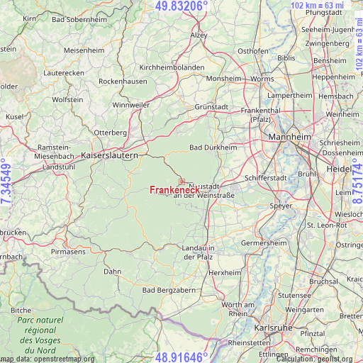
Frankeneck GPS coordinates[2]
49° 22' 35.004" North, 8° 2' 54.996" East
| Map corner | latitude | longitude |
|---|---|---|
| Upper-left | 49.83206°, | 7.34549° |
| Center: | 49.37639°, | 8.04861° |
| Lower-right: | 48.91646°, | 8.75174° |
| Map W x H: | 101.8×101.8 km | = 63.3×63.3mi |
| max Lat: | 55.01917° ⇑77.5% North |
| Frankeneck: | 49.37639° |
| min Lat: | ⇓22.5% South 47.40724° |
| min Long | Frankeneck | max Long |
| 5.92978° | 8.04861° | 14.98853° |
| W 23.7%⇐ | ⇒76.3% E |
Elevation
Elevation of Frankeneck is 231 m = 758 ft, and this is 18.1 m = 59 ft below average elevation for this country.
| Max E: |
1256 m = 4121 ft | 49.3% |
| Avg. | 249.1 m = 817 ft | |
| Frankeneck | 231 m = 758 ft | |
Min E: |
-5 m = -16 ft | 50.7% |
See also: Germany elevation on elevation.city.
Geographical zone
Frankeneck is located in North temperate zone (between Tropic of Cancer and the Arctic Circle). Distance of this North polar circle is 1911 km =1187.4 mi to North.| Distance of | km | miles | from Frankeneck |
|---|---|---|---|
| North Pole | 4516.9 | 2806.7 | to North |
| Arctic Circle | 1911 | 1187.4 | to North |
| Tropic Cancer | 2884.2 | 1792.2 | to South |
| Equator | 5490.1 | 3411.4 | to South |


Nearby cities:
15 places around Frankeneck: (largest is in red/bold)
• Deidesheim
10.4 km =6.5 mi,  70°
70°
• Edenkoben
11.8 km =7.3 mi,  151°
151°
• Elmstein
8.4 km =5.2 mi,  262°
262°
• Esthal
4.8 km =3 mi,  279°
279°
• Forst
11.6 km =7.2 mi,  61°
61°
• Frankenstein
8.8 km =5.5 mi,  324°
324°
• Kirrweiler
11.8 km =7.3 mi,  135°
135°
• Lambrecht
1.9 km =1.2 mi,  110°
110°
• Lindenberg
3.6 km =2.2 mi,  83°
83°
• Maikammer
9.9 km =6.2 mi, 142°
• Neidenfels
1.4 km =0.9 mi,  353°
353°
• Neustadt
7.2 km =4.5 mi, 114°
• Ruppertsberg
11 km =6.8 mi, 76°
• Sankt Martin
9.4 km =5.8 mi, 154°
• Weidenthal
5.7 km =3.5 mi, 321°
Sources, notices
• [Note1] Compared only with cities in Germany existing in our database
• [Src1] Map data: © OpenStreetMap contributors (CC-BY-SA)
• [Src2] Other city data from geonames.org with taken over terms of usage.
• [Src3] Geographical zone / Annual Mean Temperature by Robert A. Rohde @ Wikipedia
